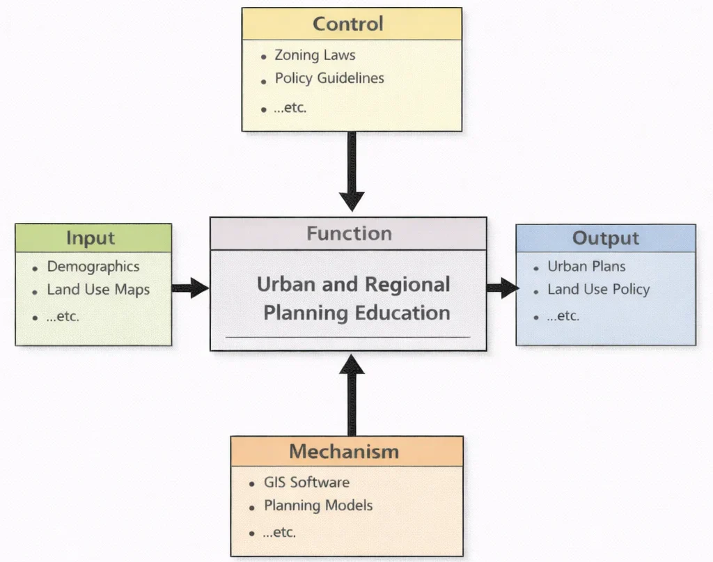
Urban and Regional Planning Education can be understood as an organised way of turning the messiness of real places into decisions people can live with. As the diagram suggests, the learning process begins with inputs such as demographics and land-use maps—evidence about who lives where, how land is used, and what patterns are emerging. That evidence does not act alone; it is shaped by controls like zoning laws and policy guidelines, which set the legal and ethical boundaries for what is allowed and what is desirable. Students then rely on mechanisms—GIS software, planning models, and related analytical tools—to translate raw information into scenarios, trade-offs, and defensible recommendations. The result is a set of outputs that look practical and public-facing: urban plans, land-use policy proposals, and other planning deliverables that connect long-term vision with on-the-ground constraints.
Urban and Regional Planning shapes the physical, economic, and social fabric of communities by guiding the development and organization of towns, cities, and metropolitan areas. In partnership with Civil Engineering, planners design infrastructure that supports both growth and sustainability, balancing land use with the needs of housing, transportation, and green space. Successful planning also hinges on insights from Construction Management to ensure timely and efficient project execution.
Natural hazards, urban heat, and climate threats demand collaboration with specialists in Earthquake and Disaster Engineering to make cities resilient. Equally vital is the support from Geotechnical Engineering, especially in regions with challenging soils or terrain. For high-rise development and urban load distribution, principles from Structural Engineering guide building codes and zoning standards.
Urban mobility depends on Transportation Engineering for creating efficient road networks, public transit systems, and pedestrian infrastructure. Sustainable cities are further supported by Water Resources Engineering, which ensures adequate supply, stormwater management, and flood resilience.
Increasingly, modern planning integrates technologies from Electrical and Electronic Engineering, enabling smarter urban systems. Applications range from traffic lights powered by Power Systems Engineering to real-time data collection via Instrumentation and Measurement tools.
The digital transformation of cities also relies on Internet of Things (IoT) and Smart Technologies, which power smart streetlights, waste collection, and building energy systems. These advances are underpinned by foundational work in Electronics Engineering and Embedded Systems and Microelectronics.
Effective communication between planning departments, residents, and automated services depends on Communication Engineering and Control Systems Engineering, which support responsive management systems and adaptive traffic control. In high-density areas, noise and electromagnetic interference are addressed using Signal Processing.
Planning also engages with emerging technologies such as Quantum Electronics and Robotics and Automation in E&E for applications like automated urban surveillance and robotic maintenance of public infrastructure. With sustainability at the core, innovations from Renewable Energy and Energy Storage are vital for powering green buildings and mass transit.
Urban planning must consider air quality, water safety, and ecological preservation, drawing upon the expertise of Environmental Engineering. Projects aimed at monitoring emissions benefit from Air Quality Engineering, while long-term strategies to protect communities from climate disruptions stem from Climate Change Mitigation and Adaptation.
Finally, ecological balance in urban settings is enhanced by principles from Ecological Engineering, which encourages the integration of green spaces, biodiversity corridors, and nature-based solutions into city planning. Together, these disciplines shape inclusive, sustainable, and resilient environments for present and future generations.
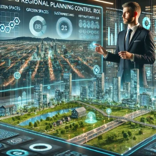
This image portrays urban and regional planning as a blend of design vision and evidence-based decision-making. The illuminated skyline represents dense urban development, while the 3D “city-on-a-table” model highlights how planners study land use at multiple scales—streets, housing areas, green parks, water systems, and transport corridors. Floating dashboards labeled with themes like sustainability and control suggest the tools planners use: GIS mapping, scenario modelling, zoning analysis, and performance indicators (walkability, environmental impact, public services, and infrastructure capacity). The strong contrast between built-up towers and green space emphasizes planning’s central challenge—supporting economic activity and housing needs while protecting quality of life and the environment. Overall, the illustration communicates planning as coordinated long-term thinking about how people live, move, work, and thrive across a whole region.
Urban and Regional Planning – Invisible FAQ
- What is urban and regional planning?
- Urban and regional planning is a coordinated process for organising land use, transport, housing, infrastructure and public spaces across cities and wider regions so that development is efficient, sustainable and socially inclusive.
- How does regional planning differ from urban planning?
- Urban planning focuses on the neighbourhood, town or city scale, while regional planning looks at larger territories that may include several cities, suburbs and rural areas, coordinating transport, economic development and environmental protection across administrative boundaries.
- Why is urban and regional planning important today?
- Planning is essential for managing rapid urbanisation, limiting sprawl, reducing congestion and emissions, protecting ecosystems, and ensuring equitable access to housing, jobs and services in both growing cities and smaller communities.
- What are the key elements of a good urban plan?
- Typical elements include land use zoning, transport and mobility networks, housing and density strategies, green and blue infrastructure, public facilities such as schools and hospitals, and policies for economic development, heritage conservation and climate resilience.
- What challenges do contemporary planners face?
- Contemporary challenges include informal settlements, housing affordability, climate change, infrastructure deficits, social inequality, fragmented governance and the need to integrate new technologies while keeping human needs at the centre of planning.
- What is the role of public participation in planning?
- Public participation allows residents and stakeholders to share local knowledge, express priorities and scrutinise proposals, leading to more legitimate, context-sensitive and inclusive plans and reducing conflict during implementation.
- How do smart cities and digital tools affect urban planning?
- Smart city concepts introduce sensors, data platforms and digital services that help monitor mobility, energy use and service delivery. Planners use these tools for evidence-based decisions while also addressing privacy, governance and digital divide concerns.
- What is mixed-use development in an urban context?
- Mixed-use development combines residential, commercial, institutional and recreational functions in the same area or even the same building, supporting walkability, shorter commutes and more vibrant public life.
- Why are green spaces and ecological networks important in planning?
- Green spaces and ecological corridors improve air quality, provide cooling, manage stormwater, support biodiversity and offer recreation and mental health benefits, making cities more resilient and liveable.
- How does planning respond to climate change and natural hazards?
- Planning responds through land use controls that avoid high-risk areas, resilient infrastructure design, low-carbon transport and building strategies, nature-based solutions for flooding and heat, and long-term adaptation plans at city and regional scales.
Table of Contents
The Scope of Urban and Regional Planning
Urban and regional planning is a multifaceted discipline that addresses how physical space is organized and developed across varying geographic scales—from small neighborhoods to metropolitan regions and even inter-regional corridors. Planners aim to integrate economic, social, and environmental considerations to create livable, efficient, and sustainable communities. This scope continues to evolve in response to global urbanization, climate pressures, technological change, and shifting socio-political dynamics. The following key components highlight the breadth of this important field:
- Land Use Planning: Land use planning involves making informed decisions about how land should be designated and utilized, whether for residential housing, commercial buildings, industrial facilities, recreational parks, or agricultural zones. The objective is to create a functional and aesthetically pleasing spatial arrangement that minimizes land conflicts and maximizes public benefit. Through zoning regulations, development codes, and urban design guidelines, planners can shape compact cities that encourage walkability and mixed-use development. Additionally, strategic land use planning can help preserve cultural heritage sites, manage urban sprawl, and protect ecologically sensitive areas.
- Transportation Planning: Transportation planning forms the backbone of regional connectivity and economic activity. It focuses on building multimodal networks that include roads, public transit systems, bike lanes, pedestrian paths, and freight corridors. Effective transportation planning seeks to reduce congestion, improve road safety, and lower greenhouse gas emissions. Integrating smart mobility solutions—such as real-time traffic monitoring, autonomous vehicles, and intelligent transport systems—can transform urban mobility experiences. Planners must also ensure that transport infrastructure is equitable, reaching marginalized communities and connecting underserved regions to employment centers and essential services.
- Environmental Planning: Environmental planning integrates ecology with urban development by promoting the sustainable management of land, water, air, and biodiversity. It includes impact assessments, green infrastructure, and hazard mitigation strategies. Planners aim to minimize negative environmental effects by guiding development away from floodplains, wetlands, and other ecologically sensitive areas. Incorporating climate adaptation measures—such as permeable pavements, urban forests, and solar-ready buildings—helps cities withstand climate shocks. Environmental planners also play a key role in advancing the goals of the United Nations Sustainable Development Goals (SDGs), especially those related to sustainable cities and climate action.
- Economic Development: Economic development planning focuses on fostering resilient economies by coordinating infrastructure investment with business incentives and labor market development. Planners may identify strategic growth corridors, propose innovation districts, and support small- and medium-sized enterprises (SMEs) to stimulate inclusive economic growth. In regions with declining industries, planners may facilitate economic diversification through creative economies, green jobs, and technology hubs. Urban regeneration projects, especially in post-industrial areas, often involve aligning private investment with public goals to rejuvenate underutilized land and stimulate commercial activity. The ultimate aim is to create job opportunities, reduce poverty, and enhance regional competitiveness.
- Social Planning: Social planning emphasizes equity, inclusion, and human well-being in the urban context. It involves forecasting demographic changes, understanding community needs, and facilitating the provision of essential services such as housing, education, public health, childcare, and eldercare. Planners advocate for affordable housing, inclusive public spaces, and equitable access to amenities. They may also facilitate participatory planning processes to ensure that historically marginalized populations have a voice in shaping their environments. Social planning is particularly vital in addressing systemic inequalities, improving urban safety, and promoting community cohesion in diverse urban landscapes.
In summary, urban and regional planning integrates technical, environmental, economic, and social considerations into a cohesive framework for shaping the future of our living spaces. By thoughtfully aligning policies with spatial strategies, planners help forge communities that are sustainable, prosperous, and inclusive for generations to come.
Principles of Urban and Regional Planning
Sustainability
Sustainability lies at the heart of modern urban and regional planning. It focuses on developing communities in ways that preserve environmental integrity, support economic vitality, and promote social well-being across generations. Planners must consider how today’s decisions affect tomorrow’s population and resources. This includes managing urban growth to prevent the overconsumption of land and water, reducing carbon emissions, and enhancing ecosystem services. Integrating green infrastructure, promoting sustainable building practices, and designing low-carbon transport systems are all essential components of sustainable urban planning.
One major strategy is to reduce dependence on non-renewable energy sources. This involves minimizing fossil fuel usage by transitioning toward cleaner alternatives such as wind, solar, and geothermal power. Compact city forms that prioritize density and mixed land uses help reduce the need for car travel, cutting down on emissions and energy consumption. In addition, encouraging green building certifications and energy-efficient infrastructure supports long-term sustainability goals. By adhering to frameworks like the UN Sustainable Development Goals, cities can align planning objectives with global environmental and social benchmarks.
- Reducing reliance on fossil fuels through improved transit, green building codes, and electrification of vehicles.
- Promoting renewable energy sources by supporting clean energy infrastructure such as solar farms and wind turbines.
- Encouraging compact, mixed-use developments to minimize sprawl, preserve agricultural land, and reduce infrastructure costs.
Equity
Equity ensures that all community members, regardless of income, race, age, gender, or ability, have fair access to the benefits of urban development. Equitable urban planning goes beyond physical infrastructure to address social injustices and historical patterns of exclusion. This includes creating inclusive zoning policies, expanding affordable housing, enhancing access to education and healthcare, and addressing environmental burdens disproportionately borne by marginalized communities. Transit-oriented development and universal design principles also help improve accessibility for the elderly, disabled, and low-income populations.
Equity in planning requires intentional community engagement and impact assessment to prevent displacement or gentrification. It emphasizes redistributing opportunities and services to underserved areas through public investment and inclusive governance. For example, incorporating social equity metrics in urban development plans helps monitor progress toward fairer outcomes. According to the Lincoln Institute of Land Policy, equitable planning is critical for fostering inclusive, thriving, and resilient cities.
Efficiency
Efficiency in urban and regional planning refers to the optimal use of space, infrastructure, and financial resources to deliver maximum public benefit with minimal waste. This includes land use optimization, integrated transportation systems, and scalable service delivery models. Efficient planning encourages mixed-use zoning, which allows residential, commercial, and institutional functions to coexist within compact areas—thereby reducing commuting distances and infrastructure redundancy.
Infrastructure investments must be strategically coordinated to support long-term goals and maximize return on investment. Planners assess factors such as energy use, water supply, waste management, and mobility to ensure that cities operate smoothly and economically. Advanced tools like Geographic Information Systems (GIS) and data analytics support real-time decision-making to fine-tune efficiency in urban systems. Furthermore, digital technologies and smart city applications improve service delivery while reducing operational costs and environmental impact.
Resilience
Resilience is the capacity of cities and regions to absorb disturbances, adapt to changing conditions, and quickly recover from adverse events. In the face of increasing climate change threats, natural disasters, pandemics, and economic volatility, resilience planning has become a central pillar of urban development. Key strategies include reinforcing critical infrastructure, updating building codes, implementing flood control systems, and developing early-warning mechanisms for extreme weather events.
Social resilience is equally important—it involves building strong community networks, supporting vulnerable populations, and promoting health equity. Ecological resilience is enhanced by protecting green spaces, wetlands, and biodiversity corridors that act as buffers during crises. Economic resilience, meanwhile, is achieved by diversifying industry bases and fostering innovation. These multi-dimensional strategies help ensure that cities can not only survive but thrive amid future uncertainties.
Public Participation
Public participation ensures that urban planning reflects the actual needs and aspirations of the communities it serves. Involving residents, stakeholders, and civil society organizations in the planning process builds trust, improves transparency, and strengthens democratic governance. Engagement methods range from town hall meetings and digital surveys to participatory budgeting and co-design workshops. When communities feel a sense of ownership over urban policies, implementation is smoother and more impactful.
Public involvement is particularly vital in contexts with diverse populations and competing interests. It enables inclusive dialogue, resolves conflicts, and produces more innovative and acceptable solutions. Effective participation also helps identify local knowledge and insights that experts might overlook. Long-term partnerships between planners and communities foster accountability and sustainability in project outcomes, ultimately enhancing the social legitimacy of planning decisions.
Key Components of Urban and Regional Planning
Urban Planning
Urban planning plays a critical role in shaping the form and function of cities. It involves creating and implementing policies and design strategies that manage how land is used, how infrastructure is developed, and how people interact within urban environments. A major objective is to accommodate growing populations while maintaining a high quality of life and minimizing negative impacts such as traffic congestion, air pollution, and social segregation. Planners must carefully consider housing densities, economic zoning, and land accessibility to build inclusive and vibrant communities that support diverse populations and lifestyles.
Effective urban planning also addresses historic preservation, smart energy usage, sustainable construction, and the equitable distribution of public services. The principles of smart growth guide many modern urban strategies by promoting walkable neighborhoods, compact building design, and diverse housing choices. Parks, green corridors, and recreational spaces are also incorporated to promote mental and physical well-being and foster social cohesion.
- Zoning Laws: These establish which land parcels can be used for residential, commercial, industrial, or mixed-use purposes. Zoning enables organized growth and helps prevent land use conflicts by designating areas for specific activities and development forms.
- Smart Growth: This strategy supports environmentally friendly, economically sustainable, and socially equitable communities. It promotes transit-oriented development, limits urban sprawl, and emphasizes accessibility to public services and employment centers.
- Public Spaces: Thoughtfully designed public realms such as urban plazas, green belts, and pedestrian zones increase livability and inclusiveness. They also contribute to urban resilience by reducing heat islands and improving stormwater absorption.
Regional Planning
Regional planning provides a larger-scale vision for coordinated development across multiple municipalities, including cities, towns, and rural settlements. It ensures that transportation, housing, environmental, and economic strategies work in harmony beyond individual administrative boundaries. Planners aim to reduce disparities between urban and rural areas and support holistic, integrated growth. Regional frameworks are vital in addressing cross-border issues such as watershed management, commuter flows, industrial zones, and natural disaster mitigation. These plans often form the basis for state or national development strategies and play a key role in economic resilience and ecological stewardship.
- Economic interdependence between urban and rural areas fosters strong regional ties, enabling resource sharing, labor market integration, and balanced growth across the territory.
- Infrastructure systems such as highways, railways, energy corridors, and water supply networks must be harmonized across the region to ensure efficient mobility and service delivery.
- Environmental conservation efforts help preserve key regional assets like forests, rivers, and biodiversity corridors, ensuring long-term ecological balance and climate adaptation capacity.
Housing and Community Development
Safe, affordable, and accessible housing is a foundational goal of planning. Housing strategies must address both immediate needs and long-term community development goals. Planners assess housing demand, monitor affordability trends, and propose zoning solutions to accommodate diverse household types and income levels. Programs may include housing vouchers, cooperative housing models, and inclusionary zoning policies. Community development goes beyond shelter to include the creation of socially inclusive neighborhoods with essential amenities such as childcare centers, schools, clinics, public transit, and safe public spaces.
- Inclusionary zoning ensures that new developments include a mix of market-rate and affordable housing to promote socio-economic integration and prevent displacement.
- Rehabilitation of older housing stock preserves historic character while improving safety, energy efficiency, and livability in aging neighborhoods.
- Developing community amenities such as sports fields, libraries, and eldercare facilities enhances local identity and community well-being.
Transportation and Mobility
Mobility systems are essential to the functioning of both urban and regional areas. Planning in this area includes developing roads, rail networks, public transit systems, cycling lanes, and pedestrian infrastructure. An efficient transportation network reduces commute times, improves air quality, and facilitates economic activity. Planners must also consider the needs of underserved groups, including people with disabilities and low-income residents, to ensure that transportation systems are equitable and inclusive. Emerging trends in electric vehicles, autonomous transit, and shared mobility platforms are reshaping mobility planning across the globe.
- Reducing traffic congestion and pollution through public transit, cycling infrastructure, and pedestrian pathways is vital for urban livability and sustainability.
- Designing multimodal transport systems—integrating buses, subways, trains, and bike-sharing—ensures seamless and efficient movement of people and goods.
- Enhancing last-mile connectivity, especially in suburban and rural areas, bridges accessibility gaps and ensures equitable access to opportunities and services.
Environmental Planning
Environmental considerations are integrated into every level of planning to promote long-term sustainability and reduce the negative impact of human activity on ecosystems. Planners develop strategies to manage natural resources, improve air and water quality, and support climate adaptation. Green infrastructure, such as urban wetlands, green roofs, and tree-lined streets, helps mitigate urban heat and stormwater runoff. Environmental planning also includes hazard mitigation efforts that protect communities from floods, wildfires, and erosion. Agencies use modeling tools and ecological surveys to assess vulnerabilities and guide conservation efforts aligned with policies such as those outlined by the U.S. Environmental Protection Agency.
- Mitigate urban heat islands through tree planting, reflective materials, and landscape design that cools and shades built environments.
- Implement low-impact development techniques such as rain gardens, bioswales, and permeable pavements to manage runoff and recharge aquifers.
- Preserve biodiversity and protect critical habitats by limiting development in ecologically sensitive zones and establishing conservation easements.
Economic Development Planning
Planning plays a vital role in catalyzing regional economic growth by supporting industry, innovation, and employment generation. It involves identifying strategic areas for investment, promoting workforce development, and aligning infrastructure with economic goals. Planners also aim to diversify economies to reduce dependence on a single industry and enhance resilience to market fluctuations. Special attention is given to supporting entrepreneurship, preserving cultural assets, and fostering creative economies. Incentives, public-private partnerships, and tax policies are tools frequently used to attract and retain businesses in priority sectors.
- Attracting businesses and industries to planned economic zones creates job opportunities and strengthens local tax bases.
- Promoting tourism and cultural heritage, including through preservation and destination branding, supports local economies and community pride.
- Supporting local entrepreneurship through incentives, incubators, and access to microfinancing nurtures small business ecosystems and innovation.
Disaster Risk Management
With increasing climate change impacts and urban vulnerability, disaster risk management has become an integral part of urban and regional planning. Planners develop strategies to reduce exposure to hazards and enhance recovery capacity. These include site selection criteria that avoid high-risk areas, retrofitting infrastructure, and conducting community education programs. Plans also include detailed emergency protocols and resource allocation frameworks that kick in during crises. Collaboration with emergency responders, civil society, and technical agencies ensures that risk mitigation is both proactive and community-centered.
- Designing flood-resistant infrastructure such as elevated roads, levees, and retention basins reduces long-term flood damage in vulnerable areas.
- Enforcing strict building codes in seismic zones improves structural safety and reduces casualties during earthquakes and tremors.
- Creating evacuation routes and disaster response plans ensures preparedness and rapid coordination in the event of natural or human-induced disasters.
Tools and Techniques in Urban and Regional Planning
- Geographic Information Systems (GIS)
GIS is an indispensable tool in modern urban and regional planning, enabling professionals to map, analyze, and visualize spatial data across multiple scales and variables. GIS technology helps planners make data-driven decisions by integrating diverse datasets—such as demographics, topography, infrastructure, and environmental conditions—into layered visual representations. This multi-dimensional insight supports the evaluation of urban expansion, resource allocation, and policy outcomes. GIS is also used to detect zoning inconsistencies, assess flood risks, simulate land-use scenarios, and support emergency response planning.
- Identify suitable locations for development by overlaying environmental, economic, and infrastructural data to prioritize sites with the highest potential and least risk.
- Analyze population density and land use patterns to determine where new housing, commercial zones, or public amenities should be located for balanced growth.
- Monitor environmental changes such as deforestation, wetland loss, or urban heat islands, using GIS dashboards to guide mitigation strategies.
Planners increasingly rely on GIS platforms like Esri ArcGIS to streamline workflows, improve accuracy, and collaborate across disciplines. These tools empower governments, NGOs, and private developers to evaluate spatial relationships and forecast planning outcomes with greater precision.
- Urban Modeling
Urban modeling involves the use of computational simulations and predictive algorithms to assess how proposed developments will influence the structure and function of urban systems. Models can simulate traffic flow, air pollution levels, housing affordability, and energy consumption. These insights help planners make evidence-based decisions regarding zoning changes, infrastructure investments, and environmental protection. For example, a transportation model can reveal how a new subway line might reduce congestion or shift commuting patterns. Land-use models, meanwhile, simulate growth under different regulatory scenarios to support smart growth policies. Tools such as agent-based modeling and system dynamics modeling allow planners to test “what-if” scenarios and assess unintended consequences before implementation.
- Public Engagement Platforms
Inclusive and participatory planning processes are vital for creating spaces that meet the needs of all community members. Digital public engagement platforms have revolutionized how planners gather feedback, share updates, and build consensus. These tools include interactive maps, online surveys, mobile apps, virtual town halls, and social media channels. Platforms such as Bang the Table allow stakeholders to comment on proposed developments, vote on community priorities, and co-create solutions in real-time.
Public engagement platforms not only increase transparency but also help planners reach traditionally underrepresented groups such as non-English speakers, the elderly, and persons with disabilities. These platforms can host multilingual content, accessibility features, and tools that allow for anonymous contributions. Engaging the public early and often fosters trust, reduces opposition, and leads to more equitable and context-sensitive outcomes.
- Remote Sensing
Remote sensing involves collecting data about the Earth’s surface using satellite imagery, aerial photography, or drone technology. This technique allows planners to assess large and often inaccessible areas quickly and cost-effectively. Remote sensing helps track land cover changes, detect urban sprawl, assess deforestation, monitor water quality, and map heat islands. It is especially useful in regions lacking up-to-date cadastral or infrastructure records. High-resolution imagery supports planning in disaster-prone areas, enabling the identification of vulnerable structures and populations. Remote sensing also plays a vital role in climate change monitoring, helping identify long-term trends in sea-level rise, glacial retreat, and vegetation loss.
- Data Analytics
The use of big data and machine learning is transforming how urban systems are understood and optimized. Data analytics enables planners to derive insights from massive, real-time datasets—such as mobile phone records, transit usage, sensor networks, and social media feeds. These insights inform a range of planning decisions, from predicting housing demand to optimizing energy distribution. Machine learning algorithms can detect hidden patterns in urban behavior, forecast land value changes, and recommend infrastructure upgrades. Predictive analytics is particularly valuable for identifying emerging trends before they escalate into problems. For instance, early indicators of gentrification or traffic congestion can trigger timely interventions.
By integrating data analytics into planning practice, cities become more responsive, adaptive, and proactive. This data-centric approach supports smart city initiatives, improves service delivery, and enhances quality of life across diverse communities.
Challenges in Urban and Regional Planning
- Urbanization
Urbanization, particularly in developing countries, is occurring at an unprecedented pace. Cities are absorbing millions of new residents every year, placing immense pressure on housing stock, transport systems, sanitation, and other essential services. This rapid growth often outpaces infrastructure development, leading to the expansion of informal settlements or slums lacking access to clean water, electricity, and healthcare. Inadequate planning responses result in traffic congestion, increased pollution, and deteriorating living standards. Managing urban growth requires integrated strategies that combine land use regulation, infrastructure investment, and public-private partnerships to promote compact and inclusive urban forms.
Planners must also anticipate future growth by incorporating demographic trends, migration patterns, and economic forecasts. However, they frequently contend with outdated or inaccurate data, making proactive planning difficult. Spatial planning tools such as urban growth boundaries, zoning reforms, and transit-oriented development are essential to guide orderly expansion. According to UN population projections, by 2050 nearly 70% of the world’s population will live in urban areas, amplifying the urgency of addressing this challenge through smart and sustainable policies.
- Climate Change
Climate change poses one of the most pressing and complex challenges for urban and regional planning. Cities are increasingly vulnerable to extreme heat, rising sea levels, intense storms, droughts, and flooding. Planners must embed climate resilience into all aspects of development—from building codes and zoning laws to green infrastructure and disaster risk management. Coastal cities face especially high risks, as they may need to relocate vulnerable populations, fortify shorelines, and retrofit aging infrastructure to withstand surging seas.
Adaptation strategies include creating heat-resistant urban landscapes with tree cover and reflective materials, incorporating floodable parks, and designing resilient energy and water systems. Mitigation efforts must focus on reducing carbon footprints through energy-efficient buildings, sustainable transport networks, and renewable energy integration. Urban planning also plays a key role in meeting global climate commitments, such as those outlined in the Paris Agreement, by facilitating low-carbon development pathways and enhancing carbon sinks through green spaces.
- Resource Scarcity
Urban and regional planners must grapple with the finite nature of critical resources such as land, water, and energy. As urban populations grow, so do demands for housing, food production, and infrastructure—yet available land is often limited and unevenly distributed. Water scarcity is another pressing issue in many cities, driven by over-extraction, pollution, and climate-induced variability. Ensuring a stable energy supply, particularly from renewable sources, also requires strategic planning and investment.
Balancing these competing demands necessitates careful prioritization and the use of integrated resource management approaches. Land use planning must reconcile the needs for conservation, agriculture, housing, and industry. Planners are increasingly adopting circular economy principles, encouraging resource efficiency through recycling, wastewater reuse, and local energy generation. Advanced technologies, such as smart metering, water harvesting, and decentralized energy systems, are becoming part of the planner’s toolkit for addressing resource limitations sustainably.
- Social Inequality
Persistent social inequality undermines the goal of creating inclusive, livable, and equitable cities. Marginalized populations often reside in under-served neighborhoods, far from jobs, schools, healthcare, and public amenities. Urban planning must actively address systemic discrimination and disparities by promoting affordable housing, mixed-income communities, and equitable transit access. Inclusive zoning, public land allocations for social housing, and participatory budgeting are tools that help redistribute resources and empower disadvantaged communities.
Racial, gender, and income disparities are often embedded in historical planning decisions, such as redlining and exclusionary zoning, which have long-term effects on generational wealth and access to opportunity. Today’s planners are increasingly focused on equity-oriented practices that prioritize community engagement and recognize the lived experiences of vulnerable groups. Promoting equity is not just a moral imperative but also a practical one—cities that invest in inclusive growth are more stable, productive, and cohesive over the long term.
- Political and Financial Constraints
Planning projects frequently encounter resistance due to shifting political agendas, bureaucratic inertia, and limited funding. Changes in leadership can reverse or stall long-term planning initiatives, while conflicting interests between government agencies, developers, and communities can delay implementation. Public skepticism, misinformation, and lack of trust can also undermine support for vital reforms or infrastructure projects. Financial barriers are particularly acute in lower-income regions where tax bases are narrow and international aid is inconsistent.
To overcome these constraints, planners must build strong institutional frameworks, cultivate political consensus, and design projects with long-term financial sustainability. Mechanisms such as land value capture, public-private partnerships, and climate financing instruments can help secure necessary funds. Strategic communication and transparent stakeholder engagement are critical for maintaining public and political support. Ultimately, successful planning requires resilience not just in the physical environment but in governance and financial systems as well.
Future Trends in Urban and Regional Planning
- Smart Cities
Smart cities represent a transformative vision for the future of urban living, integrating advanced digital technologies into the fabric of city management. These cities rely on interconnected systems driven by the Internet of Things (IoT), artificial intelligence (AI), and big data analytics to improve efficiency, reduce costs, and enhance the quality of life. Smart city initiatives are being implemented to manage everything from traffic flow and lighting to public safety and emergency response.
- Leveraging IoT and AI to optimize infrastructure and services includes using predictive analytics to manage traffic congestion, monitor air quality, and allocate energy resources efficiently. AI can help automate city services and enable dynamic pricing models for utilities and transportation.
- Using smart sensors for real-time monitoring of traffic, waste, and energy systems allows for adaptive responses to shifting urban conditions. For example, intelligent traffic signals can reduce gridlock, while smart bins notify collection teams when full, improving waste management logistics.
As cities grow more complex, platforms like Smart Cities Council provide essential frameworks and resources for guiding digital urban transformation globally.
- Sustainable Urbanism
Sustainable urbanism focuses on reducing the environmental footprint of cities by rethinking how urban spaces are designed, built, and managed. It emphasizes compact, walkable neighborhoods, renewable energy usage, low-carbon transport, and responsible water and waste management. The integration of green infrastructure—such as bioswales, rain gardens, and permeable pavements—helps cities mitigate climate impacts and support biodiversity.
- Designing carbon-neutral neighborhoods involves using net-zero buildings, passive solar design, energy-efficient materials, and district heating systems. Urban districts are being planned to function with minimal reliance on fossil fuels.
- Promoting urban farming and green roofs enhances food security, improves air quality, and reduces the heat island effect. These practices reconnect residents with nature and create multifunctional green spaces in dense environments.
Organizations like Urban Institute explore strategies to implement sustainable communities that are economically, socially, and ecologically viable for the long term.
- Resilient Cities
Resilience in urban planning is the capacity of cities to absorb shocks and stresses while maintaining essential functions. This trend has gained prominence due to the increasing frequency of natural disasters, pandemics, and economic disruptions. Planners now integrate resilience into all dimensions of city development—from critical infrastructure and housing to health systems and supply chains.
- Incorporating flood barriers, stormwater management systems, and disaster-ready infrastructure protects cities from floods, hurricanes, and other environmental hazards. Examples include elevated roads, green buffer zones, and emergency response shelters.
- Adapting coastal cities to rising sea levels requires dynamic seawalls, floating architecture, and strategic retreat planning. These adaptive measures must be grounded in strong scientific models and community-based design.
Global networks such as the Resilient Cities initiative by ICLEI help cities build long-term capacity to handle evolving risks.
- Inclusive Growth
Inclusive growth ensures that the benefits of urban development are shared across all social, economic, and cultural groups. It prioritizes equity, diversity, and accessibility as foundational goals of urban and regional planning. Planners aim to create places that offer equal opportunities for employment, education, healthcare, and civic participation.
- Prioritizing affordable housing and inclusive public spaces fosters community integration and prevents gentrification-induced displacement. Affordable units must be strategically located near transit, jobs, and amenities.
- Encouraging diverse, mixed-income communities helps counteract segregation and social isolation. Zoning reforms, housing subsidies, and community land trusts are among the tools used to facilitate inclusive neighborhoods.
Equitable cities are more resilient and sustainable over time, making inclusivity a non-negotiable component of future planning frameworks.
- Decentralized Planning
Decentralized planning reflects a paradigm shift away from mega-city dominance toward more balanced regional development. It aims to empower smaller cities, towns, and rural communities to become self-sufficient and economically vibrant. This strategy reduces the burden on congested urban centers and encourages more equitable national growth patterns.
- Supporting smaller cities and rural areas to reduce pressure on major urban centers involves infrastructure upgrades, investment incentives, and regional development programs. These interventions can stimulate job creation, improve service delivery, and enhance quality of life outside urban cores.
- Promoting telecommuting and digital connectivity to enable remote working allows people to reside in less dense areas while staying connected to economic hubs. The COVID-19 pandemic accelerated this trend, prompting greater investment in broadband infrastructure and digital literacy programs.
Decentralized planning contributes to territorial cohesion and opens new pathways for innovation and localized resilience.
Case Studies in Urban and Regional Planning
Singapore
Singapore is internationally recognized as a leading example of comprehensive and forward-thinking urban planning. Despite its limited land area of just over 700 square kilometers and a population exceeding 5 million, the city-state has managed to transform itself into one of the most efficient, sustainable, and livable urban environments in the world. Its planning success is rooted in long-term visioning, integrated policy frameworks, and rigorous enforcement of planning regulations.
- Integrated land use and transportation planning ensures that housing, employment centers, and amenities are well-connected by a world-class mass rapid transit (MRT) system and extensive bus networks. High-density, mixed-use developments are carefully located near transit hubs to reduce reliance on private vehicles.
- Emphasis on green spaces and vertical gardens is evident in projects such as Gardens by the Bay and Parkroyal on Pickering, where greenery is embedded into architecture. More than 40% of Singapore’s land is devoted to greenery, supporting biodiversity and enhancing the urban climate.
- Advanced public housing policies, spearheaded by the Housing and Development Board (HDB), provide affordable, quality homes to over 80% of the population. Public housing integrates amenities such as schools, shops, and sports facilities, promoting social cohesion and inclusivity.
Singapore’s Urban Redevelopment Authority (URA) has adopted cutting-edge digital planning tools, including the Digital Planning Lab, to simulate and optimize future development scenarios. This has helped the city remain agile in responding to economic shifts, climate change, and demographic trends.
Curitiba, Brazil
Curitiba, a mid-sized city in southern Brazil, is celebrated globally for its pioneering approach to sustainable urban transportation and human-centered development. Under the leadership of visionary mayor Jaime Lerner during the 1970s, Curitiba adopted bold planning strategies that reshaped its urban form without large-scale capital investment.
The most notable innovation is its Bus Rapid Transit (BRT) system, introduced in 1974. Unlike traditional bus services, Curitiba’s BRT features dedicated bus lanes, pre-paid boarding stations, and high-frequency service. It provides metro-like efficiency at a fraction of the cost, reducing traffic congestion and lowering emissions. The system has been replicated in over 160 cities worldwide, earning Curitiba a reputation as a model for cost-effective transit planning.
Beyond transport, Curitiba has embraced green planning by allocating significant space to parks and green corridors. It has also implemented waste recycling programs and citizen education initiatives to build environmental awareness. The city’s commitment to accessible, affordable public spaces and mobility has positioned it as a beacon of sustainability in the Global South.
The BRT Standard developed by the Institute for Transportation and Development Policy (ITDP) acknowledges Curitiba’s influence in establishing best practices for high-quality bus-based transit.
Netherlands
The Netherlands, a low-lying country vulnerable to sea-level rise, is a global leader in resilient urban planning, particularly in water management. Dutch cities such as Rotterdam and Amsterdam have integrated hydrological thinking into urban design, creating cities that coexist with water rather than resisting it.
Rotterdam’s approach includes multi-functional flood control infrastructure like water plazas, which double as recreational areas during dry weather and temporary retention basins during heavy rains. Green rooftops, permeable pavements, and canal networks complement these efforts, enhancing ecological performance and urban livability.
The Dutch “Room for the River” program exemplifies adaptive planning by redesigning landscapes to allow rivers to safely overflow in designated zones, protecting urbanized areas downstream. This philosophy shifts from defensive flood barriers to holistic ecosystem-based adaptation strategies.
Urban planners in the Netherlands also emphasize public engagement, sustainability, and innovation in design. Collaborative platforms, smart modeling, and stringent building codes ensure that resilience and aesthetics are harmonized. As climate threats intensify, Dutch cities offer valuable lessons for flood-prone urban regions across the globe.
Why Study Urban and Regional Planning
Designing Functional and Inclusive Communities
Urban and regional planning involves creating environments that support quality of life and economic development. Students learn how to design land use, zoning, and public spaces. This ensures that communities are functional, accessible, and inclusive.
Balancing Growth and Sustainability
Students explore strategies to accommodate population growth while preserving the environment. They study urban sprawl, resource management, and climate adaptation. This promotes resilient and sustainable urban development.
Policy Analysis and Public Engagement
The course emphasizes community consultation and evidence-based decision-making. Students learn how to conduct surveys, analyze data, and work with diverse stakeholders. This fosters democratic and transparent planning processes.
Infrastructure and Transportation Planning
Students study how to integrate housing, transit, and utility infrastructure into coherent plans. They learn to coordinate between different sectors and levels of government. This supports efficient and cost-effective urban systems.
Global Perspectives and Local Challenges
Urban planners work on challenges such as housing shortages, gentrification, and disaster resilience. Students are prepared to apply global best practices in local contexts. The field offers opportunities to make cities more equitable and responsive.
Urban and Regional Planning: Conclusion
Urban and regional planning stands as a vital and ever-evolving discipline that brings together multiple fields—ranging from architecture, engineering, and environmental science to economics, sociology, and public policy—to create livable, equitable, and sustainable spaces. As cities and regions grapple with mounting complexities such as climate change, demographic shifts, technological disruptions, and increasing social inequality, the role of planning becomes more critical than ever. It serves not only to organize space and resources but to mediate competing interests, anticipate future needs, and ensure long-term resilience.
At its core, urban and regional planning is about people. It is about creating environments that foster health, inclusion, opportunity, and a high quality of life for all residents. This involves balancing development with preservation, growth with sustainability, and efficiency with empathy. Whether it’s crafting walkable neighborhoods, designing integrated transport systems, managing regional ecosystems, or providing affordable housing, planners are tasked with making decisions that affect both present and future generations.
The field is increasingly driven by innovative tools such as Geographic Information Systems (GIS), predictive modeling, and artificial intelligence, which enhance the precision and responsiveness of planning strategies. These technologies help planners simulate future scenarios, optimize land use, and adapt to emerging threats. At the same time, the importance of inclusive, participatory processes cannot be overstated. Engaging communities in shaping their built environment strengthens social cohesion, encourages civic responsibility, and ensures that diverse voices are reflected in final outcomes. As highlighted by the American Planning Association, ethical and inclusive planning is foundational to democratic society and effective governance.
Moreover, sustainability has become a guiding principle across all levels of planning practice. From zero-carbon buildings to regional green belts and transit-oriented development, urban and regional planning is increasingly aligned with global climate goals and sustainable development frameworks. Initiatives such as the UN-Habitat Urban Planning and Design Programme promote people-centered urban design that is environmentally sound, socially inclusive, and economically viable.
Looking ahead, the future of urban and regional planning will be defined by adaptability, interdisciplinarity, and innovation. Planners must continue to build on a foundation of evidence-based policy, stakeholder engagement, and ethical responsibility to guide the evolution of cities and regions in a way that is both forward-looking and grounded in local realities. As humanity becomes increasingly urbanized, the stakes are higher—but so too is the opportunity to shape environments that are more just, resilient, and harmonious with nature.
Ultimately, urban and regional planning is not just about constructing roads, zoning plots, or regulating density. It is about shaping the human experience—how we move, live, interact, and thrive in a rapidly changing world. With careful foresight, collaborative visioning, and sustainable action, planners will continue to play a central role in building cities and regions that reflect our highest aspirations for society and the planet.
Urban and Regional Planning – Frequently Asked Questions (FAQ)
1. What does an urban and regional planner actually do?
Planners analyse how land is currently used, consult with communities, and prepare plans and policies that guide where homes, workplaces, roads, parks and public facilities should go. They also review development proposals to ensure they align with long-term goals for a city or region.
2. How is planning different from architecture or civil engineering?
Architecture focuses on designing individual buildings, and civil engineering on the technical design of infrastructure like roads and bridges. Planning looks at the bigger picture: how whole neighbourhoods, cities and regions fit together socially, economically and ecologically.
3. Why do we need plans instead of letting cities grow “naturally”?
Without planning, cities often grow in a fragmented and inequitable way, leading to sprawl, congestion, unsafe housing and environmental damage. Planning helps coordinate growth so that infrastructure, services and housing keep pace with population change.
4. What is meant by “smart city” in the context of planning?
A smart city uses digital technologies and data to manage transport, energy, water and public services more efficiently. For planners, this means integrating sensors, real-time data and digital participation tools into how they analyse problems and test ideas.
5. How can planning make cities more socially inclusive?
Inclusive planning ensures affordable housing, accessible public spaces, barrier-free transport and equal access to jobs, schools and healthcare. It actively incorporates the voices of marginalised groups in decision-making and seeks to reduce spatial segregation.
6. What role do parks and green spaces play in urban and regional planning?
Green spaces are planned as part of wider ecological and recreational networks. They provide places for exercise and relaxation, support biodiversity, mitigate urban heat and manage stormwater, contributing directly to public health and climate resilience.
7. How does regional planning support rural areas as well as cities?
Regional planning coordinates transport, economic development and environmental protection across city–rural systems. It can support rural livelihoods, protect agricultural land and natural habitats, and ensure smaller towns are connected to jobs and services in larger cities.
8. What skills are useful if I want to study urban and regional planning?
Useful skills include critical thinking, spatial awareness, basic statistics, interest in maps and GIS, writing and communication skills, and curiosity about how social, economic and environmental factors shape real places.
9. How does planning relate to climate change mitigation and adaptation?
Planning can reduce emissions by supporting compact, transit-oriented development, walking and cycling, and energy-efficient buildings. It also helps cities adapt by steering growth away from high-risk areas and integrating nature-based solutions for flooding, heat and storms.
10. What types of careers can a planning background lead to?
Graduates may work in government planning departments, consulting firms, transport agencies, environmental organisations, community development groups, or research and policy roles focused on cities and regions.
Urban and Regional Planning: Review Questions and Answers
Urban and regional planning looks at how land, infrastructure and communities fit together over time. The questions below help you consolidate key ideas about how planners shape cities and regions to be more liveable, resilient and fair.
-
What is urban and regional planning, and why is it important?
Answer: Urban and regional planning is the process of analysing, designing and managing land use, transport networks, public spaces and infrastructure to create efficient, sustainable and liveable communities. It is important because it helps balance economic growth, environmental protection and social equity, ensuring that both urban and rural areas can develop in a way that supports quality of life for present and future generations. -
What are the key elements of urban planning?
Answer: Key elements of urban planning include:- Land use zoning: deciding which areas are used for housing, workplaces, industry and recreation.
- Transportation systems: planning roads, public transit, walking and cycling networks.
- Housing strategies: providing a mix of housing types and affordability levels.
- Environmental sustainability: protecting green spaces, water bodies and air quality.
- Economic planning: supporting local jobs, commercial centres and innovation districts.
- Public services: locating schools, healthcare, utilities and community facilities where people can access them easily.
-
How does regional planning differ from urban planning?
Answer: Urban planning focuses on the scale of towns and cities, dealing with neighbourhood layouts, local transport and community facilities. Regional planning operates at a larger geographical scale, coordinating multiple cities, suburbs and rural areas. It addresses issues such as regional transport corridors, watershed management, strategic housing and employment locations, and the distribution of major infrastructure across an entire region. -
What challenges do modern urban planners face?
Answer: Modern planners must respond to rapid urbanisation, informal settlements and housing affordability pressures, as well as chronic traffic congestion and increasing car dependence. They also face environmental challenges such as climate change, flooding and air pollution, and must work to ensure that vulnerable groups are not excluded from access to housing, jobs, green spaces and public services. -
How do smart cities integrate technology into urban planning?
Answer: Smart cities integrate digital technologies—such as the Internet of Things (IoT), artificial intelligence and big data analytics—into how urban systems are monitored and managed. Planners use real-time data on traffic, energy use and environmental conditions to design more responsive transport systems, optimise infrastructure performance, and support new forms of citizen engagement through online platforms and participatory mapping tools. -
What role does public participation play in urban planning?
Answer: Public participation ensures that planning decisions reflect the lived experiences, needs and priorities of residents. Through community workshops, public hearings, surveys and online engagement, planners gather feedback, refine proposals and build support for long-term plans. Meaningful participation increases transparency, strengthens trust and often leads to more equitable and context-sensitive outcomes. -
How does transportation planning contribute to sustainable cities?
Answer: Transportation planning supports sustainability by prioritising public transport, walking and cycling, and by designing compact, mixed-use neighbourhoods that reduce the need for long car trips. Measures such as dedicated bus lanes, integrated ticketing, safe cycling networks and pedestrian-friendly streets lower emissions, reduce congestion and improve access for people who do not own cars. -
What are the benefits of mixed-use development in urban areas?
Answer: Mixed-use development combines housing, shops, offices and community facilities within the same area or even the same building. This reduces travel distances, supports walkability and public transport, and creates lively streets with activity throughout the day. It can also make more efficient use of infrastructure and land compared to single-use zoning. -
What is the significance of green spaces in urban planning?
Answer: Green spaces such as parks, urban forests and river corridors are vital for physical and mental health, providing places for recreation and relaxation. They also improve air quality, reduce the urban heat island effect, enhance stormwater management, and create habitats for urban biodiversity. Planned green networks can link neighbourhoods and contribute to overall city resilience. -
How do urban planners address climate change in city and regional development?
Answer: Planners address climate change by promoting low-carbon transport and building patterns, protecting and expanding green and blue infrastructure, and steering new development away from high-risk areas such as floodplains or unstable slopes. They also encourage energy-efficient building design, support renewable energy integration, and develop long-term adaptation and mitigation strategies at both city and regional scales.
Urban and Regional Planning: Exploratory Questions and Answers
1. How can urban planning balance economic development and environmental sustainability?
Urban planning must integrate economic growth with environmental stewardship by promoting green infrastructure, mixed-use development, and sustainable transportation. Strategies like incentivizing green buildings, enhancing public transit, and preserving natural habitats help balance economic expansion while minimizing ecological footprints. Smart zoning laws also ensure that industrial growth does not harm residential areas or ecosystems.
2. What role does transportation planning play in shaping livable and resilient cities?
Efficient transportation planning improves accessibility, reduces congestion, and lowers emissions. Cities can implement public transit networks, bike lanes, and pedestrian-friendly infrastructure to enhance mobility. Adaptive traffic management using smart signals and AI-driven data analytics can reduce delays and optimize urban movement.
3. How does affordable housing fit into sustainable urban development?
Affordable housing ensures economic diversity, reduces social inequality, and fosters community stability. Integrating affordable housing into urban centers reduces long commutes, enhances quality of life, and prevents gentrification-driven displacement. Policies like rent controls, inclusionary zoning, and public-private partnerships can create sustainable and equitable housing solutions.
4. How can urban planners make cities more resilient to climate change?
Cities can integrate green roofs, permeable pavements, and flood-resistant infrastructure to mitigate climate risks. Planning for rising sea levels, increasing heatwaves, and unpredictable weather patterns through improved drainage systems and sustainable building designs enhances resilience. Renewable energy integration and carbon-neutral policies further future-proof urban environments.
5. In what ways does regional planning support rural and suburban development?
Regional planning coordinates transportation, housing, and economic policies across multiple areas, ensuring balanced growth and preventing overurbanization. It connects rural economies with urban markets, improves public service accessibility, and fosters regional economic diversification.
6. How can smart city technologies enhance urban and regional planning?
Smart cities use data analytics, IoT, and AI to optimize energy consumption, manage traffic, and improve public services. Real-time monitoring of air quality, water usage, and waste management enables proactive responses to urban challenges. Smart grids and automated systems improve sustainability and efficiency.
7. What challenges arise in creating walkable, pedestrian-friendly urban spaces?
Limited space, automobile-centric infrastructure, and resistance to change can hinder walkability efforts. Overcoming these challenges requires pedestrian-first zoning, traffic-calming measures, and integrating urban greenery to encourage walkable environments. Cities like Copenhagen and Amsterdam demonstrate successful pedestrian-centric models.
8. How can urban planning encourage social inclusion and cultural diversity?
Inclusive urban planning designs public spaces, transportation, and housing policies to accommodate diverse populations. Mixed-income housing, multilingual public services, and culturally inclusive urban design promote social cohesion. Ensuring accessibility for all, including people with disabilities, enhances urban equity.
9. How does land-use planning impact public health in urban areas?
Proper zoning prevents pollution exposure, ensures access to green spaces, and promotes active lifestyles through walkable neighborhoods. Eliminating food deserts, reducing industrial emissions near residential areas, and incorporating community gardens can significantly improve urban health outcomes.
10. What are the advantages and disadvantages of vertical urban expansion (high-rise development) versus horizontal expansion (urban sprawl)?
Vertical expansion maximizes space efficiency, reduces transportation needs, and preserves natural land, but can lead to overcrowding and high infrastructure costs. Urban sprawl increases housing availability but strains transportation networks, increases reliance on cars, and leads to habitat loss. Balanced development strategies optimize both approaches.
11. How can urban planners integrate renewable energy into city infrastructure?
Planners can design cities with solar panels on buildings, wind energy integration, and district heating systems. Policies promoting net-zero buildings, energy-efficient public lighting, and electric vehicle infrastructure contribute to urban sustainability. Incentives for renewable energy adoption can accelerate this transition.
12. What policies can governments implement to ensure sustainable urban expansion?
Governments can enforce zoning regulations that promote mixed-use development, green infrastructure, and public transit access. Investment in climate-resilient housing, sustainable construction materials, and incentives for energy-efficient buildings ensures long-term urban sustainability.