
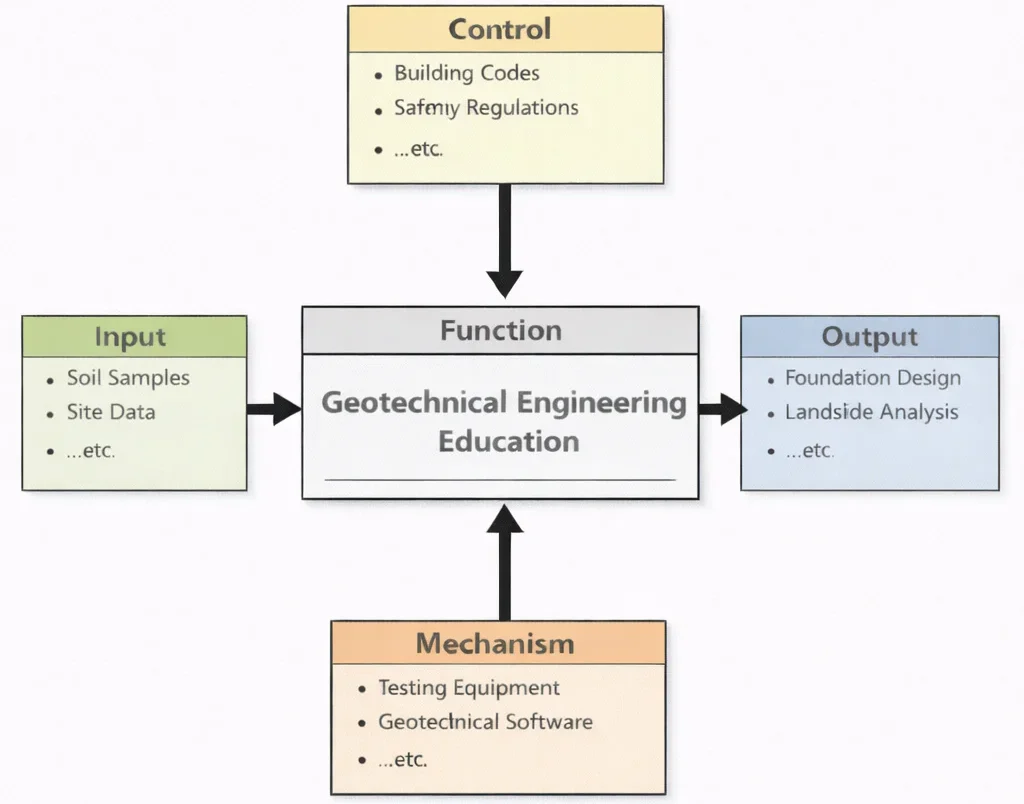
Geotechnical Engineering Education, as shown in the diagram, is a structured learning “engine” that transforms raw risk knowledge into actionable engineering judgment. Students begin with inputs like soil samples and site data—stratigraphy, historical borehole records, groundwater tables, and field penetration resistance—so they can understand ground behavior not as an unpredictable mystery, but as measurable physical mechanics acting beneath every built asset. Their thinking is then disciplined by controls such as building codes and safety regulations, which act like guardrails: they define allowable bearing pressures, maximum permissible settlements, and ethical responsibilities when public structures and foundations are at stake.
With mechanisms such as geotechnical software and specialized laboratory/field testing equipment, learners move beyond theory into evidence-based practice—modeling seepage lines, exploring slope failure slip surfaces, interpreting oedometer settlement curves, and stress-testing foundation assumptions before ground is broken on site. The outputs are not just technical skills, but practical readiness: the ability to propose robust foundation designs and to conduct landslide risk assessments that connect soil parameters to structural safety, excavation shoring, and long-term ground stability. In this way, the education function turns variable subsurface conditions into definitive engineering decisions—helping future engineers build environments anchored on solid ground.
Geotechnical Engineering plays a foundational role in the built environment by analyzing the behavior of soil, rock, and underground water systems to ensure safe and stable infrastructure. Rooted in the broader discipline of Civil Engineering, it supports the design of everything from buildings and roads to dams and tunnels. Through this field, students gain insights into subsurface conditions that influence engineering decisions and mitigate construction risks.
Practical applications often intersect with Construction Management, where site preparation, excavation planning, and soil stabilization techniques are guided by geotechnical evaluations. Moreover, infrastructure resilience in the face of natural calamities is enhanced through integration with Earthquake and Disaster Engineering, which draws upon seismic soil dynamics.
The mechanical behavior of earth materials is closely linked to the load transfer systems designed within Structural Engineering. In tandem, Transportation Engineering uses geotechnical input to design foundations for highways, tunnels, and railway embankments. Broader considerations, such as land use and zoning, further involve professionals in Urban and Regional Planning.
Geotechnical principles are also essential in Water Resources Engineering, where soil permeability and erosion control influence flood management, dam safety, and groundwater movement. The increasing demand for multidisciplinary approaches brings collaboration with Electrical and Electronic Engineering to incorporate advanced sensing and monitoring solutions.
Technologies such as Instrumentation and Measurement and Embedded Systems and Microelectronics are used to assess soil stress, pore water pressure, and vibrations during pile driving or excavation. Sophisticated feedback loops managed through Control Systems Engineering can adjust construction protocols in real time.
The use of Internet of Things (IoT) and Smart Technologies allows for automated field instrumentation and data logging, supporting efficient ground condition assessments. Coupled with tools from Signal Processing, this data enables precise interpretation of soil behavior.
Geotechnical specialists are also becoming increasingly involved in sustainability projects through Environmental Engineering. Techniques to control erosion, reduce construction impact, and improve soil remediation overlap with the goals of Air Quality Engineering and Ecological Engineering.
In an era of climate uncertainty, collaborations with Climate Change Mitigation and Adaptation initiatives have elevated the importance of terrain stability and adaptive land use planning. Other interdisciplinary opportunities arise through Biomedical Electronics, where biomechanics of earth and human interaction converge in disaster safety design.
Future trends point toward deeper integration with automation, such as using Robotics and Automation in E&E for geotechnical exploration and Power Systems Engineering for managing energy needs at remote construction sites. Innovations in Quantum Electronics may further transform subsurface sensing technologies and predictive modeling.

Geotechnical Engineering: Foundations, Soil Behaviour, and Subsurface Systems
Civil Engineering Curriculum Navigation Hub
Explore key specialized disciplines within Civil Engineering to understand how soil properties, groundwater flow, structural foundations, and terrain stability connect across the built environment:
Civil Engineering – Overview
Provides the core structural and environmental context, connecting subsurface site characterization with macro-scale infrastructure delivery.
Geotechnical Engineering (Current)
Investigates soil and rock mechanics, ground permeability, and slope stability to design robust shallow and deep foundation systems.
Structural Engineering
Relies on bearing capacity and settlement data to ensure building loads and column reactions are safely transferred into competent soil layers.
Earthquake & Disaster Engineering
Evaluates dynamic soil response, soil-structure interaction, and liquefaction hazards during severe seismic ground motion events.
Water Resources Engineering
Analyzes subsurface seepage, pore water pressures, and hydraulic piping to protect earth dams, levees, and groundwater aquifers.
Construction Management
Coordinates heavy earthmoving, temporary excavation shoring, pile driving operations, and ground improvement logistics on site.
Transportation Engineering
Designs subgrade compaction, pavement sub-base layers, railway embankments, and tunnel support structures for long-term load performance.
Urban & Regional Planning
Incorporates geological risk mapping, landslide hazard zones, and soil suitability studies into municipal zoning and land development masterplans.
Key Areas of Geotechnical Engineering
Geotechnical engineering is the cornerstone of any structure that meets the ground. By examining and mastering subsurface conditions, this discipline ensures foundations, slopes, and earthworks are designed safely, sustainably, and cost-effectively.
1. Soil Mechanics
The science of soil mechanics is essential for understanding how soils behave under various loads, moisture changes, and environmental conditions.
- Shear Strength: Engineers evaluate how soil resists sliding according to the Mohr-Coulomb failure criterion (\(\tau_f = c' + \sigma' \tan\phi'\)); critical for foundation stability and slope safety.
- Compressibility: Understanding Terzaghi 1D consolidation theory helps predict primary and secondary settlement of buildings or embankments.
- Permeability: Determines water flow through soil via Darcy's Law (\(v = k \times i\))—crucial for drainage, seepage control, and groundwater modeling.
- Moisture Sensitivity: Expansive montmorillonite clays swell upon wetting and shrink upon drying—knowledge vital for preventing foundation heave and structural cracking.
- Soil Classification: Systems like the Unified Soil Classification System (USCS) and AASHTO guide engineering property correlation and behavior prediction.
2. Rock Mechanics
Rock mechanics explores the behavior of rock masses, which often differ vastly from soils due to intact rock strength versus structural discontinuities.
- Stress-Strain Behavior: Laboratory unconfined compressive strength (UCS) and triaxial tests determine deformability and elastic moduli.
- Fracture & Joint Analysis: Identifying strike, dip, persistence, and roughness of joint sets that govern kinematically possible wedge or planar failures in rock slopes.
- Rock Mass Characterization: Classification systems like Rock Mass Rating (RMR) and Geological Strength Index (GSI) guide tunnel support and dam foundation design.
- Hard Rock Applications: Engineering high-rise foundation sockets, cavern excavations, and underground hydroelectric powerhouse facilities.
3. Foundation Engineering
Designing foundations that transfer structural loads safely to stable ground is the essence of geotechnical responsibility.
- Shallow Foundations: Isolated spread footings, strip footings, and compensated raft mats suitable for competent near-surface ground.
- Deep Foundations: Driven precast piles, continuous flight auger (CFA) piles, and large-diameter drilled shafts for transferring loads through weak strata to bedrock.
- Settlement Analysis: Evaluating both immediate elastic settlement and time-dependent consolidation settlement to satisfy structural serviceability limit states.
- Bearing Capacity: Utilizing general bearing capacity formulations (Terzaghi, Meyerhof, Vesic) to verify ultimate shear margins.
- Pile Testing: Executing static load tests, high-strain dynamic testing (PDA), and low-strain pile integrity testing (PIT) to confirm structural and geotechnical resistance.
4. Slope Stability & Landslide Control
Ensuring natural and built slopes remain stable is vital in hilly and urban regions.
- Stability Analysis: Employing 2D/3D limit equilibrium method of slices (Bishop, Janbu, Morgenstern-Price) and finite element shear strength reduction (SSR).
- Landslide Mitigation: Designing passive soil nail grids, post-tensioned ground tiebacks, retaining structures, regrading benches, and sub-horizontal drains.
- Monitoring: Incorporating borehole inclinometers, surface prisms, and vibrating-wire piezometers for early-warning movement detection.
- Cut-and-Fill Excavations: Ensuring slope safety during highway construction, railway alignments, and urban hillside terraces.
5. Earthquake Geotechnical Engineering
Seismic events alter ground behavior; geotechnical engineers must anticipate dynamic soil-structure interactions.
- Liquefaction Assessment: Calculating cyclic stress ratios (CSR) and cyclic resistance ratios (CRR) from SPT and CPT soundings.
- Seismic Hazard Analysis: Evaluating ground motion amplification across local soil strata profiles (Site Classes A through F).
- Foundation Dynamics: Designing foundations to accommodate lateral spreading kinematic pile bending and dynamic inertia forces.
- Earthquake-Induced Settlement: Estimating post-liquefaction reconsolidation settlement and lateral flow deformation.
6. Ground Improvement Techniques
When natural ground lacks adequate strength or stiffness, engineers engineer the earth itself.
- Chemical Stabilization: Deep soil mixing (DSM) and jet grouting using cement, lime, or slag binders to create stabilized ground columns.
- Dynamic Compaction: Dropping heavy tamper weights (10–30 tonnes) from heights up to 25 meters to densify loose granular deposits.
- Vibro Techniques: Vibro-compaction and vibro-replacement stone columns for granular fills and soft cohesive deposits.
- Consolidation Acceleration: Prefabricated vertical drains (PVD / wick drains) combined with surcharge preloading to accelerate pore pressure dissipation.
- Geosynthetics: High-strength geogrids, woven geotextiles, and geocells providing basal reinforcement and separation beneath embankments.
7. Subsurface Investigation & Testing
Reliable design begins with thorough investigation to eliminate subsurface surprises.
- Borehole Drilling: Rotary core drilling and wash boring to recover undisturbed Shelby tube samples and continuous rock cores.
- In-situ Testing: Standard Penetration Test (SPT), electric piezocone penetration test (CPTu), field vane shear, and pressuremeter tests.
- Laboratory Testing: Direct shear, consolidated-undrained triaxial compression, oedometer consolidation, and Atterberg limits.
- Groundwater Surveys: Standpipe piezometers and slug testing to measure seasonal phreatic heads and hydraulic conductivities.
8. Geotechnical Risk & Project Management
Engineers quantify and communicate the geological uncertainties inherent to subsurface environments.
- Probabilistic Risk Modeling: Applying Monte Carlo methods and Geotechnical Baseline Reports (GBR) to define differing site condition baselines.
- Observational Method: Modifying geotechnical design during construction based on real-time instrumentation telemetry.
- Asset Lifecycle Tracking: Monitoring retaining structures and tunnel convergence throughout operational life.
- Stakeholder Coordination: Aligning ground recommendations across structural, civil, environmental, and legal disciplines.
9. Sustainable & Innovative Solutions
Modern practice advances ecological responsibility and carbon reduction.
- Bio-mediated Ground Improvement: Microbially Induced Calcite Precipitation (MICP) utilizing ureolytic bacteria to precipitate \(\text{CaCO}_3\) cementation.
- Energy Geostructures: Embedding geothermal heat exchanger loops directly into structural foundation piles and diaphragm walls.
- Permeable Ground Systems: Designing engineered permeable fills and bioswale subgrades that facilitate aquifer recharge while maintaining vehicle loads.
For technical standards and best practices, consult authoritative resources from the ASCE Geo-Institute and technical publications via Geoengineer.org.
Systems Engineering: Foundation & Ground Improvement Trade-offs
Selecting foundation systems and ground modification strategies requires balancing structural load intensity, soil stratigraphy, installation vibration, noise limits, and lifecycle carbon emissions.
| System / Strategy | Operating Soil Mechanism | Primary Engineering Advantages | Physical Constraints & Failure Modes | Lifecycle Trade-off Synthesis |
|---|---|---|---|---|
| Shallow Spread Footings / Rafts | Direct bearing on upper competent strata; spreads vertical column stresses across horizontal contact area. | Lowest initial capital cost; straightforward formwork and reinforcement; minimal specialized site plant required. | Inadequate for heavy column loads on soft clays; highly vulnerable to differential settlement, frost heave, and soil erosion. | Preferred choice where dense sand or stiff clay is present within \(1.5\text{–}3.0\text{ m}\) of ground level; unviable for soft alluvial soils. |
| Driven Precast Concrete Piles | Shaft skin friction (\(f_s\)) plus base end-bearing (\(q_b\)) transferring loads through weak layers into dense strata. | High structural quality control (factory-cast); no soil spoil disposal needed; immediately loadable post-driving. | Severe acoustic noise and ground vibration; risk of pile toe breakage on boulders; ground heave affecting adjacent structures. | Cost-effective for open rural or industrial sites; legally constrained in dense urban infill due to noise and vibration codes. |
| Bored Cast-in-Situ Drilled Shafts | Rotary drilled boreholes socketed into bedrock; supports enormous axial compressive, uplift, and lateral shear loads. | Negligible vibration; ability to penetrate hard rock layers; single large shaft can replace a cluster of multiple driven piles. | Generation of wet soil/drilling slurry spoil requiring disposal; shaft necking or toe debris contamination during tremie concreting. | Higher plant mobilization cost; demands continuous thermal integrity profiling or crosshole sonic logging; vital for bridge piers and tall towers. |
| Vibro-Replacement Stone Columns | Vibratory probe displaces weak soil and introduces compacted aggregate columns, forming a composite reinforced ground matrix. | Increases composite bearing capacity; provides rapid vertical drainage paths mitigating liquefaction and accelerating consolidation. | Ineffective in extremely sensitive organic peats; stone columns can suffer bulging failure under heavy localized point loads. | Eliminates need for deep structural piles beneath large-footprint structures (highway embankments, warehousing, airport aprons). |
Foundation Design: Terzaghi Bearing Capacity & Settlement Safety Analysis
Problem Formulation: A continuous concrete strip footing of width \(B = 2.50\text{ m}\) is to support a commercial load-bearing shear wall. The footing base is founded at depth \(D_f = 1.50\text{ m}\) in a sandy-clay subsoil layer with effective cohesion \(c' = 25\text{ kPa}\), effective angle of internal friction \(\phi' = 25^\circ\), and moist unit weight \(\gamma = 18.5\text{ kN/m}^3\). Terzaghi bearing capacity factors for \(\phi' = 25^\circ\) are specified as \(N_c = 25.1\), \(N_q = 12.7\), and \(N_\gamma = 9.7\). Groundwater is located at great depth. Using Terzaghi's bearing capacity formulation for general shear failure:
Calculate: (1) The ultimate bearing capacity \(q_{\text{ult}}\); (2) The allowable gross bearing capacity \(q_{\text{all}}\) for a Factor of Safety \(FS = 3.0\); and (3) The maximum allowable service line load \(P_{\text{all}}\) (in \(\text{kN/m}\)) that can be sustained by the foundation.
The vertical effective overburden stress at foundation depth \(D_f = 1.50\text{ m}\) is: $$q = \gamma \times D_f = 18.5\text{ kN/m}^3 \times 1.50\text{ m} = \mathbf{27.75\text{ kPa}}$$Step 2: Calculate Ultimate Bearing Capacity (\(q_{\text{ult}}\))
Terzaghi's formula for a continuous strip footing is: $$q_{\text{ult}} = c' N_c + q N_q + 0.5 \gamma B N_\gamma$$ Evaluate each term:
- Cohesion term: \(c' N_c = 25\text{ kPa} \times 25.1 = \mathbf{627.50\text{ kPa}}\)
- Surcharge term: \(q N_q = 27.75\text{ kPa} \times 12.7 = \mathbf{352.425\text{ kPa}}\)
- Footing width term: \(0.5 \gamma B N_\gamma = 0.5 \times 18.5\text{ kN/m}^3 \times 2.50\text{ m} \times 9.7 = \mathbf{224.3125\text{ kPa}}\)
Applying the design Factor of Safety \(FS = 3.0\): $$q_{\text{all}} = \frac{q_{\text{ult}}}{FS} = \frac{1{,}204.24\text{ kPa}}{3.0} \approx \mathbf{401.41\text{ kPa}}$$ Net allowable bearing capacity: $$q_{\text{net,all}} = \frac{q_{\text{ult}} - q}{FS} = \frac{1{,}204.24 - 27.75}{3.0} = \frac{1{,}176.49}{3.0} = \mathbf{392.16\text{ kPa}}$$Step 4: Determine Maximum Allowable Applied Line Load (\(P_{\text{all}}\))
Multiplying the gross allowable bearing capacity by the footing width \(B = 2.50\text{ m}\): $$P_{\text{all}} = q_{\text{all}} \times B = 401.41\text{ kN/m}^2 \times 2.50\text{ m} = \mathbf{1{,}003.53\text{ kN/m}}$$
Slope Stability & Landslide Factor of Safety (FS) Simulator
- c' & φ' increase soil shear strength (green resisting vector).
- β (Slope Angle) increases the downslope gravity pull (red driving vector).
- ru (Pore Water Pressure Ratio) reduces internal effective friction by lubricating soil particles.
Simulated in runtime on Prep4Uni.Online
Tools and Techniques
Modern geotechnical engineering employs a wide spectrum of tools and techniques that span from laboratory-based characterization to in-situ testing and computational simulations. These methods enable engineers to gain a precise understanding of subsurface behavior and evaluate how soil and rock will respond under different loading and environmental conditions. Accurate data acquisition, interpretation, and modeling are foundational to successful design and construction of any structure that interfaces with the ground.
Laboratory Testing
Laboratory testing plays a vital role in geotechnical investigations by allowing controlled evaluation of soil and rock samples under repeatable conditions. This enables precise determination of their mechanical, hydraulic, and thermal properties. Some of the most widely used laboratory tests include:
- Triaxial Compression Tests: Assess the strength and deformation characteristics of soil under simulated in-situ stress states (Consolidated-Drained [CD], Consolidated-Undrained [CU], and Unconsolidated-Undrained [UU]). These tests yield effective stress shear parameters (\(c', \phi'\)) essential for deep foundations and slope stability.
- Atterberg Limits: Determine the consistency and plasticity of fine-grained soils. Liquid Limit (\(LL\)), Plastic Limit (\(PL\)), and Plasticity Index (\(PI = LL - PL\)) define the soil’s phase changes with moisture, predicting shrinkage and swelling potential.
- Direct Shear Tests: Evaluate drained shear strength along a pre-cut failure plane, widely used for granular backfills and rock joint characterization.
- Oedometer Consolidation Tests: Measure one-dimensional compression index (\(C_c\)), recompression index (\(C_r\)), and coefficient of consolidation (\(c_v\)) to forecast foundation settlement curves over decades.
- Permeability Tests: Constant-head and falling-head permeameters measuring hydraulic conductivity (\(k\)) for dewatering and seepage cutoff evaluations.
Field Investigations
While laboratory tests provide vital data, field investigations offer context-specific in-situ measurements that reflect natural stratification and groundwater conditions. These techniques guide the selection of foundation types and construction methods. Common field techniques include:
- Boreholes: Drilled using continuous flight augers or mud-rotary rigs to extract undisturbed Shelby tubes and split-spoon samples, while installing standpipe piezometers.
- Standard Penetration Test (SPT): A standardized empirical method counting the hammer blow count (\(N\)-value) needed to drive a split-barrel sampler \(300\text{ mm}\), correlating to soil relative density and bearing capacity.
- Cone Penetration Test (CPT/CPTu): Hydraulically pushing an instrumented cone tip at \(20\text{ mm/s}\), delivering continuous high-resolution profiles of tip resistance (\(q_c\)), sleeve friction (\(f_s\)), and dynamic pore pressure (\(u_2\)).
- Pressuremeter Testing: In-situ cylindrical expansion tests directly determining the at-rest horizontal earth pressure (\(K_0\)), shear modulus (\(G\)), and limit pressure (\(P_L\)).
- Geophysical Surveys: Non-destructive Multichannel Analysis of Surface Waves (MASW), seismic refraction, and Ground Penetrating Radar (GPR) to delineate bedrock profiles and buried voids.
Numerical Modeling
Computational modeling has revolutionized geotechnical engineering by enabling simulation of soil-structure interaction, prediction of deformation and failure modes, and risk evaluation under complex loading scenarios. Key tools include:
- Finite Element Analysis (FEA): Advanced continuum formulations simulating nonlinear elastoplastic constitutive soil models (Mohr-Coulomb, Hardening Soil, Cam-Clay) in deep excavations and tunneling.
- Finite Difference Methods (FDM): Explicit time-marching schemes (e.g., FLAC) particularly effective for large-strain geotechnical deformation and landslide flow mechanics.
- Limit Equilibrium Methods (LEM): Method-of-slices algorithms calculating overall slope factors of safety across circular and non-circular slip surfaces.
- PLAXIS and GeoStudio: Specialized commercial software suites used globally for coupled stress-deformation, transient seepage, and dynamic earthquake simulations.
- Coupled THMC Analysis: Integrating Thermo-Hydro-Mechanical-Chemical interactions for complex environmental barriers, radioactive waste repositories, and geothermal foundations.
Emerging and Integrated Techniques
- Real-Time Monitoring: Automated MEMS tiltmeters, vibrating-wire piezometers, and fiber-optic strain arrays transmitting live ground movement data to web dashboards.
- Artificial Intelligence (AI): Machine learning surrogate models predicting bearing capacity and soil stratigraphy interpolation from regional borehole data.
- BIM & Subsurface Digital Twins: Open Industry Foundation Classes (IFC) linking 3D geological strata models directly with structural foundations in BIM workflows.
For technical test standards, refer to ASTM International geotechnical test specifications and international research published in Géotechnique.
Applications of Geotechnical Engineering
Geotechnical engineering plays an indispensable role across a diverse spectrum of civil and environmental projects. Its applications extend far beyond soil classification and foundation design, touching virtually every domain where human infrastructure interacts with the Earth's surface and subsurface. Whether developing high-speed rail networks or designing resilient coastal defenses, geotechnical expertise ensures structural stability, safety, and sustainability.
-
Infrastructure Development
Geotechnical engineering forms the backbone of modern infrastructure development. From planning urban expressways to constructing megastructures, geotechnical investigations and design ensure that projects are grounded on stable and suitable terrain. Site-specific evaluations of soil bearing capacity and settlement potential are essential for determining the type and depth of foundations. In bridge construction, for instance, engineers use deep foundation systems such as piles or caissons to support heavy loads and resist lateral forces. Similarly, tunnels require rock and soil classification, ground support analysis, and groundwater control to ensure safe excavation and long-term stability. For skyscrapers, geotechnical modeling is used to predict how differential settlement might impact structural integrity. In transportation infrastructure, such as roads and railways, subgrade preparation, compaction, and drainage design are critical in preventing rutting and pavement failure. Techniques like slope reinforcement and retaining walls are employed in hilly terrain to prevent landslides and erosion. Infrastructure projects also require risk mitigation strategies during natural events such as earthquakes or floods, where geotechnical specialists contribute through seismic hazard analysis and floodplain evaluation. -
Water Resources Projects
Water resource engineering is another domain where geotechnical engineering is pivotal. Dams, levees, and reservoirs are massive structures that require detailed geotechnical assessment to address issues like seepage control, slope stability, and erosion resistance. Engineers use tools like finite element analysis to model embankment behavior under varying hydraulic loads. In dam design, for example, engineers must analyze the shear strength of embankment materials and the interaction of foundation strata with reservoir water pressure. Seepage analysis using Darcy’s law is crucial to designing internal drainage systems that prevent piping failures. Similarly, levees must be designed with attention to flood overtopping and internal erosion, particularly in densely populated flood-prone regions. Reservoirs not only demand impermeable lining systems to reduce infiltration but also require long-term monitoring to detect subsurface movements. These projects rely on geotechnical instrumentation such as piezometers, inclinometers, and seepage weirs for continuous performance evaluation. Many advances in this field are documented through sources like the U.S. Bureau of Reclamation Dam Design Guidelines, which provide in-depth standards for geotechnical dam engineering. -
Environmental Engineering
Geotechnical engineers play a critical role in safeguarding the environment, especially in managing waste and remediating polluted sites. In landfill engineering, they are responsible for designing liner systems, leachate collection mechanisms, and slope reinforcement to ensure safe containment of waste materials. Synthetic geomembranes and compacted clay liners are engineered to prevent groundwater contamination, and the entire system is monitored for settlement and leakage. Contaminated site remediation often involves soil stabilization, removal, or encapsulation. For example, heavy metal-contaminated soils may be solidified using additives such as cement or fly ash to reduce permeability and immobilize pollutants. Vertical cutoff walls using slurry trench techniques or soil-bentonite barriers are commonly employed to block contaminant migration. In the context of brownfield redevelopment, geotechnical engineers conduct soil vapor extraction assessments and ground improvement before construction. Furthermore, geotechnical techniques are vital for designing bioremediation systems that treat soil using microbial processes in situ. These efforts are supported by evolving global standards and insights published by international platforms such as the Geoengineer.org Environmental Geotechnics Portal. -
Energy Projects
The energy sector increasingly depends on geotechnical engineering to ensure safety, stability, and efficiency across a range of applications. Offshore oil and gas platforms must be anchored to seabeds with highly variable geotechnical properties. Engineers use marine geotechnical surveys and sediment coring to design pile foundations that resist cyclic loading from waves and operational equipment. For onshore wind turbines, where towers exceed 100 meters in height, soil-structure interaction and dynamic analysis are critical in foundation design. Shallow or deep foundations must accommodate the combination of vertical, horizontal, and torsional loads generated by wind forces. In geothermal energy development, subsurface investigations help determine the permeability and thermal properties of rock layers to optimize drilling and extraction. In addition, pipelines that transport oil, gas, or hydrogen across continents are evaluated for settlement risks, landslide susceptibility, and frost heave potential. Geotechnical engineers also contribute to solar farm site assessments, ensuring that expansive soils or loose sands will not affect the long-term stability of support structures. Across all these areas, their work ensures that energy infrastructure is not only cost-effective and efficient but also resilient against environmental hazards.
In summary, geotechnical engineering is the invisible yet essential foundation of countless infrastructure and environmental efforts. It connects natural geology with built systems, balancing safety, economy, and sustainability in every application—from the heights of wind turbines to the depths of tunnel networks.
Challenges in Geotechnical Engineering
Geotechnical engineering, though foundational to modern infrastructure, is fraught with multifaceted challenges that require both scientific insight and practical innovation. As construction ventures delve deeper into complex terrains and society demands more sustainable and resilient infrastructure, geotechnical engineers must confront uncertainties not only in the ground beneath their feet but also in the broader environmental and societal contexts. Below are key challenges facing the field today, each intertwined with technological, environmental, and regulatory considerations.
Uncertainty in Subsurface Conditions
- One of the most persistent challenges in geotechnical engineering is the inherent variability of subsurface materials. Soils and rocks are naturally heterogeneous, and even small changes in their composition or layering can significantly affect the stability and performance of structures.
- Engineers rely on a range of field investigations—such as boreholes, standard penetration tests, and cone penetration tests—to estimate subsurface conditions. However, these are limited in coverage, leading to potential gaps in understanding.
- As a result, conservative safety factors are often employed to mitigate risk, which can increase construction costs. Advances in geophysical techniques like ground-penetrating radar and seismic refraction are helping to improve subsurface imaging, but uncertainties remain, especially in expansive, stratified, or weathered zones. This makes real-time monitoring systems increasingly valuable in adaptive design approaches.
Climate Change Impacts
- Climate change poses a growing threat to geotechnical systems worldwide. Variability in rainfall intensity, rising groundwater levels, and prolonged droughts can drastically alter the behavior of soils.
- For example, clay soils become more expansive or contractive with changes in moisture, impacting foundation performance. In cold regions, the thawing of permafrost leads to ground subsidence, jeopardizing roads, pipelines, and buildings.
- Coastal erosion, accelerated by sea-level rise and stronger storm surges, endangers infrastructure near shorelines. These shifts demand new design strategies that consider long-term climate projections, such as flexible embankments and drainage systems that adapt to fluctuating hydrological conditions. A report from the European Climate Adaptation Platform outlines how geotechnical adaptation is integral to infrastructure resilience.
Urbanization
- As global urbanization accelerates, cities are growing both outward and downward. Urban environments pose distinct geotechnical challenges such as limited space for site investigations, increased load demands from tall structures, and the need for underground infrastructure like subways and basements.
- Deep excavations adjacent to existing buildings must be stabilized without causing ground settlement or vibrations that could damage neighboring properties. Retaining structures, ground anchors, and diaphragm walls are commonly used but require precise design and monitoring.
- Moreover, urban redevelopment often occurs on sites with complex fill materials or historical contamination, requiring remediation and ground improvement. To address these issues, engineers are turning to solutions like top-down construction and the use of fiber-reinforced soils and geosynthetics. Research on underground construction technologies continues to expand, with universities and organizations like the International Tunnelling and Underground Space Association (ITA) offering global insights.
Sustainability
- As global awareness of environmental issues increases, geotechnical engineering is under pressure to adopt sustainable practices. Traditional materials like concrete and steel have high carbon footprints, prompting the search for alternatives such as recycled aggregates, fly ash, and geopolymers.
- Engineers must also reduce soil waste generated during excavations by reusing or stabilizing materials on-site. Life-cycle assessments are being integrated into design processes to evaluate long-term environmental impacts.
- Slope stabilization, for example, can be achieved using vegetation and bioengineering techniques rather than purely mechanical solutions. Drainage systems are being designed to recharge aquifers or mitigate flooding, aligning geotechnical design with eco-hydrology goals. Moreover, sustainable land use planning—through brownfield redevelopment or low-impact construction—ensures that geotechnical engineering contributes to climate resilience rather than degradation.
Emerging Responses and Future Outlook
To overcome these challenges, the geotechnical field is embracing innovation across several fronts. Smart geotechnical systems equipped with sensors and wireless data loggers now enable continuous performance monitoring. Machine learning algorithms are being developed to analyze large volumes of geotechnical data for pattern recognition and predictive modeling. Public-private partnerships are funding large-scale research on adaptive infrastructure, especially in regions vulnerable to climate extremes. Educational institutions are also expanding their curricula to train engineers in integrated risk management, sustainability principles, and digital tools.
In summary, while geotechnical engineering faces formidable challenges, it also holds the potential to pioneer resilient, adaptive, and environmentally conscious infrastructure solutions in the face of an increasingly unpredictable world.
Future Trends in Geotechnical Engineering
As the built environment faces growing challenges from climate change, urbanization, and the need for sustainable development, geotechnical engineering is undergoing a significant transformation. Emerging technologies, innovative methodologies, and global priorities are reshaping how geotechnical professionals approach design, construction, and maintenance. Below are key trends driving the future of this essential discipline, accompanied by detailed insights into their practical implications and interdisciplinary relevance.
Digitalization and Automation
- The geotechnical sector is rapidly integrating digital tools that enhance the accuracy, efficiency, and visualization of subsurface conditions and structural responses. Building Information Modeling (BIM) allows for seamless collaboration among architects, structural engineers, and geotechnical professionals by providing a shared digital representation of the built environment.
- When paired with Geographic Information Systems (GIS), engineers can spatially analyze terrain characteristics, hazard zones, and infrastructure networks. These tools are particularly valuable in complex projects such as tunnels, dams, and coastal works, where subsurface conditions can vary dramatically over short distances.
- Additionally, automation is being introduced into field operations—for example, automated borehole drilling and robotic site surveys—thereby reducing human error and increasing safety. The convergence of BIM and GIS is paving the way for smart city modeling, where geotechnical factors are dynamically integrated into urban development plans.
Smart Geotechnical Monitoring
- Traditional geotechnical monitoring methods, such as manual piezometers or settlement plates, are giving way to more advanced and real-time systems. Smart sensors, embedded with Internet of Things (IoT) capabilities, are now being used to track soil movement, pore water pressure, vibrations, and stress-strain behavior in real time.
- This data is transmitted to centralized platforms where machine learning algorithms detect anomalies or early signs of failure. Applications include landslide-prone slopes, aging retaining structures, and soft-soil embankments.
- Remote data acquisition reduces the need for on-site personnel and allows for continuous structural health monitoring even in hazardous locations. For example, research from the UK Collaboratorium for Research on Infrastructure and Cities (UKCRIC) highlights how smart instrumentation is improving the resilience and safety of critical infrastructure.
Sustainable Practices
- Environmental concerns are prompting geotechnical engineers to adopt sustainable and low-impact approaches. One significant innovation is bio-mediated soil improvement, such as microbially induced calcite precipitation (MICP), which stabilizes soils through biologically induced mineralization. This reduces the reliance on energy-intensive techniques like cement grouting.
- Additionally, the use of recycled aggregates in earthworks and fill materials is gaining traction, minimizing construction waste and reducing the demand for virgin materials. Green retaining walls, which use vegetation to stabilize slopes, offer both aesthetic and environmental benefits.
- Drainage systems are being redesigned to recharge groundwater instead of simply diverting runoff, aligning geotechnical practices with sustainable water management goals. The Journal of Cleaner Production reports that life-cycle analysis is increasingly being used to evaluate the carbon footprint of geotechnical projects.
Resilience Against Natural Hazards
- As natural disasters become more frequent and severe due to climate change, geotechnical engineers are prioritizing infrastructure resilience. For instance, slope stabilization in mountainous regions is increasingly being designed to withstand extreme rainfall events, while coastal embankments are being upgraded to cope with sea-level rise and storm surges.
- In earthquake-prone zones, engineers are adopting base-isolated foundation systems and liquefaction-resistant soil treatments to protect buildings and bridges. These efforts are being coordinated with disaster risk management frameworks, where geotechnical risk assessments are integrated with urban planning, emergency response, and insurance modeling.
- Furthermore, rapid post-disaster geotechnical evaluations are being enhanced through drone-based surveys and geospatial AI tools. Training programs and simulation-based learning are equipping engineers with the skills to respond to multi-hazard scenarios, enhancing the agility and adaptability of the profession.
Integration of Artificial Intelligence and Machine Learning
Artificial intelligence (AI) is increasingly playing a role in predictive modeling and decision-making. Algorithms trained on historical failure data and soil properties are now used to estimate bearing capacity, settlement rates, and slope stability. These models are especially useful in locations where detailed subsurface data is unavailable, offering probabilistic assessments based on existing regional datasets. AI-enhanced site classification tools also assist engineers in selecting appropriate ground improvement strategies for complex projects.
Global Collaboration and Open Data
The future of geotechnical engineering also lies in global collaboration and the use of open data. International databases on landslides, earthquakes, and soil profiles are being shared through open-access platforms, enabling engineers and researchers to model hazard risks more accurately across regions. Cross-border initiatives, such as those sponsored by the International Society for Soil Mechanics and Geotechnical Engineering (ISSMGE), are fostering innovation and knowledge transfer. Shared learning from disaster-prone regions is accelerating the adoption of resilient geotechnical solutions in developing countries.
In summary, the future of geotechnical engineering lies in its ability to evolve in tandem with technological progress and global challenges. By embracing digitalization, sustainability, smart monitoring, and resilience strategies, the field is not only advancing the science of soil and rock behavior but also contributing meaningfully to a safer and more sustainable world.
Why Study Geotechnical Engineering
Geotechnical Engineering: Conclusion
Geotechnical engineering is far more than the study of soil and rock—it is the very science that allows civilization to anchor its structures to the Earth with confidence. As one of the most foundational branches of civil engineering, geotechnical engineering ensures that buildings, roads, bridges, tunnels, dams, and other infrastructure projects stand strong against the forces of nature and time. Its importance is increasing as urbanization accelerates, extreme weather events become more frequent, and societies expand into previously undeveloped or geologically unstable regions.
Engineering the Ground Beneath Us
From skyscrapers resting on deep piles to underground transit systems passing through complex strata, the expertise of geotechnical engineers determines the feasibility and safety of these endeavors. Their work begins with detailed subsurface investigations, including borehole drilling, soil sampling, and geophysical surveys, to determine the load-bearing capacity and other geomechanical properties of the ground. They interpret data to design safe foundations, retaining walls, embankments, and slope stabilization systems, ensuring that the superstructures above can withstand both static and dynamic forces.
Integration of Advanced Tools and Technologies
Modern geotechnical engineering integrates cutting-edge technologies such as Geographic Information Systems (GIS), remote sensing, and 3D modeling to visualize subsurface conditions with high accuracy. Numerical modeling tools like PLAXIS and FLAC are employed to simulate soil-structure interaction under various stress scenarios. Moreover, real-time geotechnical monitoring systems using Internet of Things (IoT) sensors are now deployed on high-risk sites like landslide-prone slopes and deep excavation pits. These advancements allow for predictive maintenance and early warning systems, transforming geotechnical engineering from a reactive to a proactive discipline.
Sustainability and Environmental Protection
Geotechnical engineers are also at the forefront of sustainable development. They play a key role in designing eco-friendly landfills, managing contaminated sites, and developing erosion control systems that preserve delicate ecosystems. Techniques such as bioremediation and soil nailing are increasingly used to combine environmental care with engineering stability. In addition, geotechnical practices now emphasize minimal environmental disturbance during construction and focus on materials with lower embodied carbon to meet the goals of UN Sustainable Development Goal 9 on resilient infrastructure.
Applications in Challenging Terrains
Whether in the Arctic tundra, desert sands, or mountainous regions, geotechnical engineers adapt techniques to meet local challenges. Permafrost foundations in cold climates, liquefaction mitigation in seismic zones, and landslide barriers in monsoon-affected areas are examples of how this field supports global infrastructure resilience. The demand for expertise in these areas is expected to increase with expanding transportation corridors and cross-border projects like the Belt and Road Initiative.
Supporting Disaster Risk Reduction
In disaster-prone areas, geotechnical engineering plays a pivotal role in risk mitigation. For example, well-designed slope stabilization and drainage systems can prevent deadly landslides, while proper dam foundation design averts catastrophic failures. Organizations such as the International Society for Soil Mechanics and Geotechnical Engineering (ISSMGE) offer global platforms for sharing knowledge and innovations that support disaster-resilient infrastructure.
Future Outlook and Global Impact
As the global population becomes more urbanized and infrastructure demands rise, geotechnical engineers will continue to face complex challenges. These include building on soft soils, coping with rising sea levels, and retrofitting aging infrastructure. The increasing reliance on underground spaces—for transportation, utilities, and storage—makes the role of geotechnical specialists even more critical. Collaboration with urban planners, environmental scientists, and structural engineers is essential to achieve holistic, resilient, and inclusive development outcomes.
Conclusion
Geotechnical engineering is truly the unseen pillar of modern civilization. By blending traditional wisdom with modern science, it provides the confidence to build in the most demanding conditions. As we move into an era defined by climate change, technological transformation, and sustainable development, the role of geotechnical engineers will expand from merely supporting structures to safeguarding the very stability of our built environment. Their work ensures that human progress continues—literally and figuratively—on solid ground.
Frequently Asked Questions
1. What does a geotechnical engineer actually do on a project?
A geotechnical engineer investigates subsurface conditions, interprets soil and rock data, and recommends foundations, slopes and retaining systems that are safe and economical. They may design pile foundations, evaluate slope stability, assess ground risks for tunnels, and monitor ground behaviour during construction.
2. Why can’t we just design foundations without soil tests?
Ground conditions vary dramatically, even within a single site. Without proper testing, engineers might underestimate settlement, bearing capacity or groundwater issues, leading to costly failures or overconservative designs. Site-specific investigations make designs both safer and more efficient.
3. How do cohesive and non-cohesive soils behave differently in practice?
Cohesive soils (clays) can support short-term vertical cuts and deform slowly, but may be highly compressible and sensitive to water changes. Non-cohesive soils (sands and gravels) drain quickly and behave more predictably under load, yet they can collapse or flow if not confined. Designs must reflect these differences.
4. What is the purpose of a geotechnical site investigation report?
The report summarises the ground model for a site: soil and rock layers, groundwater levels, strength and compressibility parameters, and potential hazards such as soft layers or fill. It forms the technical basis for foundation design, excavation support and construction planning.
5. How does groundwater make slopes and excavations more risky?
Groundwater increases pore water pressures, which reduces effective stress and shear strength in soils (\(\sigma' = \sigma - u\)). In slopes and excavations this can trigger instability, piping or bottom heave. Engineers therefore pay close attention to drainage, dewatering and phreatic surface control.
6. When do we choose shallow foundations instead of deep foundations?
Shallow foundations are used when competent soil or rock is available near the surface and structural loads are moderate. Deep foundations, such as piles or caissons, are chosen when near-surface soils are weak, loads are large, or uplift and lateral forces must be carried to deeper, stronger layers.
7. What does “bearing capacity failure” look like?
In a bearing capacity failure, the soil beneath a footing shears along continuous slip planes, causing sudden downward settlement, foundation tilting, or ground heaving around the footing edges. This can cause cracking in superstructures, structural misalignment, or catastrophic collapse.
8. How are slopes stabilised when they show signs of movement?
Engineers improve drainage to relieve pore water pressure, reduce slope height or bench steep sections, install reinforced earth retaining walls, drill grouted soil nails or rock anchors, and install geosynthetic reinforcement.
9. Why do retaining walls usually include drainage details?
Water trapped behind a retaining wall exerts full hydrostatic pressure in addition to lateral earth pressure, more than doubling the overturning moment. Granular backfill drainage layers, weep holes, and geocomposite drain sheets are provided to relieve pore pressure continuously.
10. What are the main geotechnical concerns during tunnelling in urban areas?
In cities, small ground volume loss can trigger differential settlement troughs that crack adjacent structures and damage buried utility trunklines. Geotechnical engineers control face pressures using closed-face Tunnel Boring Machines (EPB/Slurry), perform compensation grouting, and monitor ground deformation in real time.
Geotechnical Engineering: End-of-Page Practice Module
Section 1: Interactive Review Questions (Foundational Concepts)
1. What is the primary focus of geotechnical engineering?
2. What are the key differences between cohesive and non-cohesive soils?
3. Why is soil classification important in geotechnical engineering?
4. What are the main components of a geotechnical site investigation?
5. How does water content and groundwater condition affect soil stability?
6. What is the difference between shallow and deep foundations, and when is each used?
7. What is bearing capacity in soil mechanics, and why is it critical for foundation design?
8. What causes slope instability, and how can it be mitigated?
9. Why are retaining walls used, and what principles govern their design?
10. How does tunnelling impact geotechnical stability, and how is this managed in practice?
Section 2: Thought-Provoking & Analytical Questions
1. How can understanding soil mechanics prevent catastrophic failures in infrastructure projects?
2. Why is groundwater management critical in geotechnical engineering, especially for urban construction?
3. What factors influence the choice between shallow and deep foundations, and how does site condition play a role?
4. How do engineers assess slope stability, and what innovative solutions can be used to reinforce unstable slopes?
5. How can understanding the interaction between soil and structures improve earthquake resistance?
6. Why is soil compaction vital in construction, and what methods are most effective for different soil types?
7. How do climatic conditions influence geotechnical designs for foundations and slopes?
Section 3: Numerical Problems & Step-by-Step Solutions
1. Problem 1: Subsurface Effective Stress Profile Evaluation
Solution:
Step 1: Compute total stress \(\sigma\): $$\sigma = (3.0\text{ m} \times 17.0\text{ kN/m}^3) + (5.0\text{ m} \times 20.0\text{ kN/m}^3) = 51.0 + 100.0 = \mathbf{151.0\text{ kPa}}$$ Step 2: Compute pore water pressure \(u\): $$u = h_w \times \gamma_w = 5.0\text{ m} \times 9.81\text{ kN/m}^3 = \mathbf{49.05\text{ kPa}}$$ Step 3: Compute vertical effective stress \(\sigma'\): $$\sigma' = \sigma - u = 151.0\text{ kPa} - 49.05\text{ kPa} = \mathbf{101.95\text{ kPa}}$$
2. Problem 2: Terzaghi Ultimate Bearing Capacity for Strip Footing
Solution:
Step 1: Cohesion term: \(c N_c = 20.0 \times 17.5 = \mathbf{350.0\text{ kPa}}\)
Step 2: Surcharge term: \(\gamma D_f N_q = 18.0 \times 1.5 \times 8.8 = \mathbf{237.6\text{ kPa}}\)
Step 3: Footing width term: \(0.5 \gamma B N_\gamma = 0.5 \times 18.0 \times 2.0 \times 5.4 = \mathbf{97.2\text{ kPa}}\)
Step 4: Ultimate capacity: $$q_{\text{ult}} = 350.0 + 237.6 + 97.2 = \mathbf{684.8\text{ kPa}}$$
3. Problem 3: Allowable Net Bearing Capacity with Factor of Safety
Solution:
Step 1: Compute net ultimate bearing capacity: $$q_{\text{net,ult}} = q_{\text{ult}} - \gamma D_f = 684.8 - 27.0 = 657.8\text{ kPa}$$ Step 2: Apply Factor of Safety: $$q_{\text{net,all}} = \frac{657.8\text{ kPa}}{3.0} \approx \mathbf{219.27\text{ kPa}}$$
4. Problem 4: One-Dimensional Primary Consolidation Settlement Estimation
Solution:
Formula: \(S_c = \frac{C_c H}{1 + e_0} \log_{10}\left(\frac{\sigma'_0 + \Delta\sigma'}{\sigma'_0}\right)\)
Step 1: Compute layer factor: $$\frac{C_c H}{1 + e_0} = \frac{0.30 \times 4.0\text{ m}}{1 + 0.90} = \frac{1.20}{1.90} \approx 0.63158\text{ m}$$ Step 2: Evaluate stress ratio logarithm: $$\log_{10}\left(\frac{100 + 50}{100}\right) = \log_{10}(1.50) \approx 0.17609$$ Step 3: Compute settlement: $$S_c = 0.63158\text{ m} \times 0.17609 \approx 0.11121\text{ m} = \mathbf{111.2\text{ mm}}$$
5. Problem 5: Rankine Active Lateral Earth Pressure Force on Retaining Wall
Solution:
Step 1: Compute active earth pressure coefficient: $$K_a = \tan^2(45^\circ - \phi'/2) = \tan^2(45^\circ - 15^\circ) = \tan^2(30^\circ) = \left(\frac{1}{\sqrt{3}}\right)^2 = \frac{1}{3} \approx 0.3333$$ Step 2: Compute total active lateral force \(P_a\): $$P_a = \frac{1}{2} K_a \gamma H^2 = 0.5 \times \frac{1}{3} \times 18.0\text{ kN/m}^3 \times (5.0\text{ m})^2 = 3.0 \times 25.0 = \mathbf{75.0\text{ kN/m}}$$
6. Problem 6: Hydraulic Gradient and Darcy Seepage Discharge Velocity
Solution:
Step 1: Compute hydraulic gradient \(i\): $$i = \frac{\Delta h}{L} = \frac{0.15\text{ m}}{0.30\text{ m}} = \mathbf{0.50}$$ Step 2: Compute Darcy discharge velocity \(v\): $$v = k \times i = (2.0 \times 10^{-4}\text{ m/s}) \times 0.50 = \mathbf{1.0 \times 10^{-4}\text{ m/s}}\quad\text{(or } 0.10\text{ mm/s)}$$
7. Problem 7: Constant Head Permeability Test Hydraulic Conductivity
Solution:
Step 1: Compute cross-sectional area \(A\): $$A = \frac{\pi d^2}{4} = \frac{\pi \times (10.0\text{ cm})^2}{4} = 25\pi \approx 78.54\text{ cm}^2$$ Step 2: Convert elapsed time to seconds: \(t = 5\text{ min} \times 60\text{ s} = 300\text{ s}\)
Step 3: Calculate hydraulic conductivity \(k\): $$k = \frac{Q \times L}{A \times h \times t} = \frac{450\text{ cm}^3 \times 15.0\text{ cm}}{78.54\text{ cm}^2 \times 30.0\text{ cm} \times 300\text{ s}} = \frac{6{,}750}{706{,}860} \approx \mathbf{9.55 \times 10^{-3}\text{ cm/s}}$$