
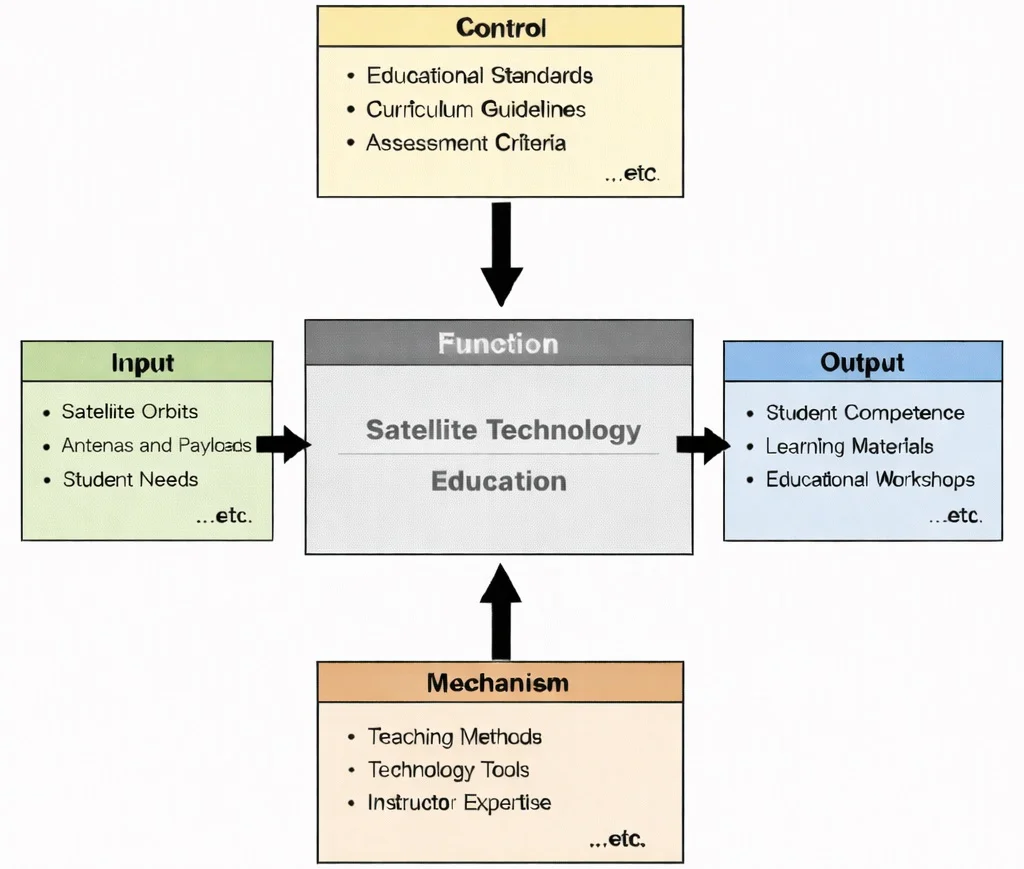
IDEF0 functional decomposition of Satellite Technology Education: orbital mechanics and payload requirements governed by international space ITU standards, realized through link-budget and orbit propagation simulation tools, and generating verified orbital design competencies.

Satellite Technology architecture: integrating Keplerian orbital mechanics, solar photovoltaic power generation, attitude determination and control systems (ADCS), and high-frequency RF/optical transponders.
This stylized space scene shows several satellites around Earth, with solar arrays and antenna dishes highlighted against a backdrop of circular orbital paths and data-style graphics. It conveys the idea of satellites as nodes in a global system—collecting signals, relaying information, and connecting ground stations through carefully designed orbits and radio links.
Satellite Systems and Orbital Operations Network
Aerospace & Aeronautical Overview
Frames satellite systems within the broader ecosystem of atmospheric and space-based engineering, serving as the foundational macro-level curriculum entry point.
Satellite Technology (Current Module)
Focuses on maintaining stable orbital platforms that support global communication, precision positioning, environmental sensing, and scientific exploration.
Celestial Mechanics
Governs the fundamental orbital motion, gravitational dynamics, timing equations, and positional geometry that dictate all spacecraft trajectories.
Spacecraft Engineering
Provides the integrated structural, electrical, and mechanical subsystem architecture that enables sustained payload performance in orbit.
Aero Control Systems & Robotics
Maintains spacecraft orientation, stabilization, and payload pointing accuracy through reaction wheels, thrusters, and feedback loops.
Avionics
Handles space-to-ground telemetry, communications links, command processing, and real-time system health diagnostic processing.
Propulsion Systems
Delivers chemical or electric thrust necessary for initial orbit insertion, station-keeping maneuvers, and collision avoidance.
Aero Materials Science
Develops advanced composite and thermal materials capable of withstanding cosmic radiation, atomic oxygen, and severe thermal cycles.
Aerospace Structures
Ensures rigid structural integrity against extreme acoustic vibrations during launch and mechanical loads during orbital deployment.
Flight Mechanics
Extends foundational classical dynamics into orbital regimes where gravitational potentials dictate orbital stability and velocity.
Hypersonics & High-Speed Aerodynamics
Governs aerothermal heating and shockwave dynamics encountered by spacecraft during atmospheric ascent and re-entry transitions.
Aerodynamics
Analyzes fluid dynamics and atmospheric drag forces during early launch vehicle staging and re-entry phases.
Core Applications of Satellites
Communication Satellites
- Geostationary Earth Orbit (GEO): Positioned at \(35,786 \text{ km}\) altitude over the equator, matching Earth's rotational period for continuous wide-area broadcast.
- Medium Earth Orbit (MEO): Operating between \(2,000 \text{ km}\) and \(35,786 \text{ km}\), serving as the backbone for global GNSS navigation constellations.
- Low Earth Orbit (LEO): Positioned between \(160 \text{ km}\) and \(2,000 \text{ km}\), providing high-throughput, ultra-low-latency broadband constellations (e.g., Starlink, OneWeb).
Navigation Satellites (GNSS)
Earth Observation and Scientific Satellites
Contemporary AI-Era Computational Paradigms in Satellite Technology
A 300 kg satellite orbits in LEO at initial altitude \(h_1 = 400.0 \text{ km}\) (\(r_1 = 6,771.0 \text{ km}\)). Due to a geomagnetic storm, average atmospheric density rises to \(\rho = 5.0 \times 10^{-12} \text{ kg/m}^3\). The satellite ballistic coefficient is \(\beta = \frac{m}{C_d A} = 50.0 \text{ kg/m}^2\). Calculate the orbital energy dissipation rate and instantaneous altitude decay rate \(\frac{dh}{dt}\):
$$\frac{dh}{dt} = -\frac{2 \rho v_r r^2}{\beta \mu}$$Step 1: Calculate circular orbital velocity \(v_r\) at \(400 \text{ km}\):
$$v_r = \sqrt{\frac{\mu}{r_1}} = \sqrt{\frac{3.986 \times 10^{14}}{6.771 \times 10^6}} = 7,672.8 \text{ m/s}$$Step 2: Evaluate altitude decay rate \(\frac{dh}{dt}\):
$$\frac{dh}{dt} = -\frac{2 \times (5.0 \times 10^{-12} \text{ kg/m}^3) \times (7,672.8 \text{ m/s}) \times (6.771 \times 10^6 \text{ m})^2}{50.0 \text{ kg/m}^2 \times (3.986 \times 10^{14} \text{ m}^3/\text{s}^2)}$$ $$\frac{dh}{dt} = -\frac{2 \times 5.0 \times 10^{-12} \times 7,672.8 \times 4.5846 \times 10^{13}}{1.993 \times 10^{16}} = -\frac{3.5157 \times 10^6}{1.993 \times 10^{16}} = -1.764 \times 10^{-10} \text{ m/s} = \mathbf{-5.56 \text{ meters/year}}$$Analysis: While nominal drag causes minor long-term decay, severe solar storms elevate density by two orders of magnitude, accelerating altitude decay to hundreds of meters per day and necessitating immediate collision avoidance or orbit-raising thruster burns.
Engineering Trade-offs in Satellite Technology
| Satellite System Trade-off | Primary Operational Benefit | Systemic Penalty / Risk | Quantitative Design Metric |
|---|---|---|---|
| LEO Mega-Constellations vs. GEO Satellites | LEO provides ultra-low latency (\(\le 25 \text{ ms}\)) and global coverage without massive single-point failure risks. | Requires thousands of satellites, rapid orbital replacement cycles, and complex ground handoff switching. | Round-trip Latency: GEO (\(\approx 600 \text{ ms}\)); LEO Constellation (\(\approx 20\text{--}40 \text{ ms}\)). |
| Laser Inter-Satellite Links (ISLs) vs. RF Ground Relays | Provides gigabit-per-second encrypted space data routing independent of ground station visibility. | Demands micro-radian optical pointing accuracy under thermal shock and structural vibration. | Optical Link Bandwidth: \(10\text{--}100 \text{ Gbps}\); Pointing Tolerance: \(\le 2.0 \text{ \mu rad}\). |
| Electric Hall Thrusters vs. Chemical Monopropellant | High specific impulse (\(I_{\text{sp}} > 2,000 \text{ s}\)) reduces required propellant mass fraction by over 70%. | Requires high electrical power generation (\(\text{kW}\) scale solar arrays); thrust levels are extremely low (\(\text{mN}\)). | Thrust-to-Power Ratio: Chemical (\(\approx 1 \text{ N/kW}\)); Hall Thruster (\(\approx 50\text{--}60 \text{ mN/kW}\)). |
| CubeSat Standardization vs. Subsystem Redundancy | Cuts development costs and schedule timelines through commercial-off-the-shelf (COTS) modular hardware. | Lacks fault-tolerant radiation-hardened redundancy; higher risk of premature component failure in orbit. | Mission Success Rate: Enterprise Satellites (\(>98\%\)); Low-Cost Academic CubeSats (\(65\text{--}80\%\)). |
Consider a LEO communication satellite operating at altitude \(h = 600 \text{ km}\) transmitting a Ka-band downlink at frequency \(f = 26.0 \text{ GHz}\). The Free-Space Path Loss (\(\text{FSPL}\)) to a ground terminal directly overhead evaluates to:
$$\text{FSPL (dB)} = 20 \log_{10}(d_{\text{km}}) + 20 \log_{10}(f_{\text{MHz}}) + 32.44 = 20 \log_{10}(600) + 20 \log_{10}(26,000) + 32.44$$ $$\text{FSPL (dB)} = 55.56 + 88.30 + 32.44 = \mathbf{176.30 \text{ dB}}$$Link Budget Closure: With transmitter power \(P_{\text{tx}} = 10 \text{ W}\) (\(+40 \text{ dBm}\)), antenna gains \(G_t = 25 \text{ dBi}\), \(G_r = 45 \text{ dBi}\), and receiver noise floor \(-108 \text{ dBm}\), received signal power is \(P_{\text{rx}} = 40 + 25 + 45 - 176.30 = -66.30 \text{ dBm}\), yielding a robust link margin of \(+41.7 \text{ dB}\). However, during heavy tropical rainfall, rain fade attenuation can exceed \(12 \text{ dB}\), requiring adaptive coding and modulation (ACM) to maintain data link continuity.
Interactive Simulator: Satellite Orbit Velocity & Period Calculator
Interactive Simulator: Satellite Orbit Velocity & Period Calculator
Adjust the orbital altitude slider to observe real-time calculations of orbital speed (v), orbital period (T), and visual trajectory scaling around Earth. Notice how increasing altitude reduces velocity while extending the orbital period.
Interactive runtime environment: https://prep4uni.online/stem/physical-technologies/aerospace-and-aeronautical-engineering/satellite-technology/
Why Study Satellite Technology
Understanding Satellite Systems and Orbits
Design and Payload Integration
Communication and Earth Observation
Spacecraft Systems and Subsystems
Future of Space Technology
Satellite Technology: Conclusion
Frequently Asked Questions
These FAQs connect basic satellite concepts to orbital mechanics, communication links, and modern space engineering challenges.
1. What exactly is a satellite in the context of STEM and everyday life?
In STEM, a satellite is any object that orbits a larger body under the influence of gravity. In everyday life, the term usually refers to artificial satellites launched into orbit around Earth to provide services such as communication, navigation, weather monitoring, and scientific observation. They form an invisible infrastructure that underpins much of our global connectivity and data systems.
2. How do different satellite orbits (like LEO and GEO) serve different purposes?
Low Earth Orbit (LEO) satellites, which orbit a few hundred to about 2,000 km above Earth, are well-suited for high-resolution imaging, scientific missions, and large constellations. Geostationary Orbit (GEO) satellites, at about 35,786 km above the equator, appear fixed in the sky and are ideal for continuous communication and weather monitoring over the same region. Engineers choose an orbit based on coverage, resolution, latency, and mission goals.
3. Why have CubeSats become so popular in modern space missions?
CubeSats are small satellites built from standardized units, which makes them cheaper, faster, and less risky to develop. Universities, research labs, and start-ups use CubeSats to test new technologies, collect localized data, and provide training for students. Their low cost and modularity have opened space access to many more organizations, stimulating innovation and STEM education.
4. How do satellites support global navigation and timing systems?
Navigation satellites continually broadcast precise time and position signals. Receivers on the ground, in vehicles, or in smartphones use signals from multiple satellites to triangulate their own position and velocity. This is the basis of Global Navigation Satellite Systems (GNSS) such as GPS, Galileo, GLONASS, and BeiDou, which support everything from aviation and shipping to ride-hailing apps and financial time-stamping.
5. What are the main subsystems inside a typical satellite?
A typical satellite includes a power subsystem (often solar panels and batteries), a communication subsystem with antennas and transponders, an attitude and orbit control system to point and position the satellite, an onboard computer for control and data handling, and the mission payload, such as cameras, scientific instruments, or communication equipment. Each subsystem must operate reliably in the harsh space environment.
6. What environmental challenges do satellites face in orbit?
Satellites must survive vacuum, extreme temperature swings between sunlight and shadow, radiation from the Sun and Earth’s belts, and potential impacts from micrometeoroids or space debris. These factors can degrade materials, damage electronics, and shorten mission lifetimes, so engineers design satellites with shielding, thermal control, and redundancy to maintain performance.
7. How are satellites powered and kept operational over many years?
Most satellites use solar panels to convert sunlight into electricity and rechargeable batteries to supply power when they pass into Earth’s shadow. Efficient power management, robust electronics, and careful thermal design help keep systems operational for many years. Critical components are often duplicated so that if one fails, a backup can take over.
8. What career and study paths connect to satellite technology?
Satellite technology brings together aerospace engineering, electrical and electronic engineering, computer science, physics, and data science. Students interested in this area can study subjects such as orbital mechanics, communications, embedded systems, and remote sensing. Careers range from satellite mission design and operations to ground-station control, data analysis, and space policy.
Satellite Technology: End-of-Page Practice Module
Section 1: Interactive Review Questions
1. What is the primary function of a satellite?
2. Name two types of orbits commonly used by satellites.
3. What is a geostationary orbit, and why is it useful?
4. What are CubeSats, and what advantages do they offer?
5. How do satellites contribute to global navigation systems?
6. What is the purpose of a satellite’s transponder?
7. What challenges do satellites face in space?
8. How do solar panels benefit satellites?
9. What role do ground control stations play in satellite operations?
10. What is satellite redundancy, and why is it important?
Section 2: Analytical & Thought-Provoking Questions
1. How do satellites maintain their designated orbits, and what factors can cause orbital decay?
2. In what ways can satellite technology be leveraged to monitor and mitigate climate change?
3. What are the ethical considerations surrounding the use of satellites for surveillance purposes?
4. How does space debris impact current satellite operations, and what measures are being taken to address this issue?
5. What role do satellites play in disaster management and emergency response?
6. How is the miniaturization of satellite technology influencing space research and commercial applications?
7. What are the challenges and benefits of deploying satellite constellations for global internet coverage?
8. How do advancements in propulsion systems enhance satellite maneuverability and mission longevity?
9. In what ways can satellite data be integrated with artificial intelligence to improve predictive analytics?
10. What are the potential environmental impacts of increased satellite launches, and how can they be mitigated?
11. How do international regulations govern the use of satellite frequencies to prevent signal interference?
12. What innovations are emerging in satellite technology to enhance global navigation systems?
Section 3: Numerical Problems & Step-by-Step Solutions
1. LEO Orbital Speed Calculation
Problem: Calculate the orbital speed (\(v\)) of a satellite in a circular Low Earth Orbit (LEO) at an altitude \(h = 500.0 \text{ km}\) above Earth's surface (Earth radius \(R_E = 6,371.0 \text{ km}\), \(\mu = 3.986 \times 10^{14} \text{ m}^3/\text{s}^2\)).
Answer:
Step 1: Compute total orbital radius (\(r\)):
\(r = R_E + h = 6,371,000 \text{ m} + 500,000 \text{ m} = 6,871,000 \text{ m}\)
Step 2: Apply the circular orbital velocity formula \(v = \sqrt{\frac{\mu}{r}}\):
\(v = \sqrt{\frac{3.986 \times 10^{14}}{6,871,000}} = \sqrt{5.8012 \times 10^7} = \mathbf{7,616.5 \text{ m/s}}\)
Step 3: Convert to kilometers per second:
\(v = \frac{7,616.5}{1,000} = \mathbf{7.62 \text{ km/s}}\)
The orbital speed of the LEO satellite is 7.62 km/s.
2. LEO Orbital Period Evaluation
Problem: Determine the orbital period (\(T\)) in minutes for the satellite at \(500.0 \text{ km}\) altitude described in Problem 1 using Kepler's Third Law (\(T = 2\pi \sqrt{\frac{r^3}{\mu}}\)).
Answer:
Step 1: Compute \(r^3\):
\(r^3 = (6.871 \times 10^6 \text{ m})^3 = 3.2438 \times 10^{20} \text{ m}^3\)
Step 2: Evaluate the Keplerian period equation:
\(T = 2 \times 3.14159 \times \sqrt{\frac{3.2438 \times 10^{20}}{3.986 \times 10^{14}}} = 6.28318 \times \sqrt{8.138 \times 10^5} = 6.28318 \times 902.108 = 5,668.1 \text{ s}\)
Step 3: Convert seconds to minutes:
\(T = \frac{5,668.1 \text{ s}}{60} = \mathbf{94.47 \text{ minutes}}\) (or \(1.57 \text{ hours}\))
The orbital period is 94.47 minutes.
3. Geostationary Orbit (GEO) Altitude Derivation
Problem: Derive the exact orbital radius \(r\) and altitude \(h\) required for a satellite to maintain a Geostationary Orbit (GEO) with a sidereal orbital period \(T = 86,164.0 \text{ s}\).
Answer:
Step 1: Rearrange Kepler's Third Law to solve for orbital radius \(r\):
\(r = \left(\frac{\mu T^2}{4\pi^2}\right)^{1/3}\)
Step 2: Substitute parameters:
\(r^3 = \frac{3.986 \times 10^{14} \times (86,164.0)^2}{39.4784} = \frac{3.986 \times 10^{14} \times 7.4242 \times 10^{9}}{39.4784} = 7.496 \times 10^{22} \text{ m}^3\)
Step 3: Take the cube root to find orbital radius \(r\):
\(r = (7.496 \times 10^{22})^{1/3} = 42,164,000 \text{ m} = 42,164.0 \text{ km}\)
Step 4: Subtract Earth's equatorial radius (\(R_E = 6,371.0 \text{ km}\)) to find altitude \(h\):
\(h = 42,164.0 \text{ km} - 6,371.0 \text{ km} = \mathbf{35,793.0 \text{ km}}\)
The exact geostationary altitude is 35,793.0 km (standard reference value: \(35,786 \text{ km}\)).
4. C-Band GEO Free-Space Path Loss Calculation
Problem: Calculate the Free-Space Path Loss (\(\text{FSPL}\)) in decibels for a satellite signal operating at downlink frequency \(f = 4,000.0 \text{ MHz}\) (C-band) transmitting from a GEO altitude of \(36,000.0 \text{ km}\).
Answer:
Step 1: Apply the standard log-form FSPL equation:
\(\text{FSPL (dB)} = 32.45 + 20 \log_{10}(d_{\text{km}}) + 20 \log_{10}(f_{\text{MHz}})\)
Step 2: Calculate distance and frequency logarithmic components:
\(20 \log_{10}(36,000.0) = 20 \times 4.5563 = 91.13 \text{ dB}\)
\(20 \log_{10}(4,000.0) = 20 \times 3.6020 = 72.04 \text{ dB}\)
Step 3: Sum the terms:
\(\text{FSPL} = 32.45 + 91.13 + 72.04 = \mathbf{195.62 \text{ dB}}\)
The total Free-Space Path Loss for the C-band GEO downlink is 195.62 dB.
5. Hohmann Transfer Delta-V for Orbit Raising
Problem: A \(1,200.0 \text{ kg}\) satellite raises its circular orbit from \(h_1 = 500.0 \text{ km}\) (\(r_1 = 6,871.0 \text{ km}\)) to \(h_2 = 1,000.0 \text{ km}\) (\(r_2 = 7,371.0 \text{ km}\)) using a Hohmann transfer ellipse. Calculate the total velocity increment (\(\Delta v_{\text{total}}\)).
Answer:
Step 1: Calculate transfer semi-major axis \(a_{\text{tx}}\):
\(a_{\text{tx}} = \frac{r_1 + r_2}{2} = \frac{6.871 \times 10^6 + 7.371 \times 10^6}{2} = 7,121,000 \text{ m}\)
Step 2: Calculate initial circular speed \(v_{c1}\) and periapsis transfer speed \(v_{\text{tx1}}\):
\(v_{c1} = \sqrt{\frac{3.986 \times 10^{14}}{6.871 \times 10^6}} = 7,616.5 \text{ m/s}\)
\(v_{\text{tx1}} = \sqrt{3.986 \times 10^{14} \left(\frac{2}{6.871 \times 10^6} - \frac{1}{7,121,000}\right)} = 7,753.1 \text{ m/s}\)
\(\Delta v_1 = 7,753.1 - 7,616.5 = 136.6 \text{ m/s}\)
Step 3: Calculate apogee transfer speed \(v_{\text{tx2}}\) and final circular speed \(v_{c2}\):
\(v_{\text{tx2}} = \sqrt{3.986 \times 10^{14} \left(\frac{2}{7.371 \times 10^6} - \frac{1}{7,121,000}\right)} = 7,227.3 \text{ m/s}\)
\(v_{c2} = \sqrt{\frac{3.986 \times 10^{14}}{7,371 \times 10^6}} = 7,353.9 \text{ m/s}\)
\(\Delta v_2 = 7,353.9 - 7,227.3 = 126.6 \text{ m/s}\)
Step 4: Compute total velocity increment \(\Delta v_{\text{total}}\):
\(\Delta v_{\text{total}} = \Delta v_1 + \Delta v_2 = 136.6 \text{ m/s} + 126.6 \text{ m/s} = \mathbf{263.2 \text{ m/s}}\)
The total velocity increment required for the Hohmann transfer is 263.2 m/s.
6. Solar Panel Electrical Power Output Calculation
Problem: Calculate the electrical power \(P\) generated by a satellite solar array with surface area \(A = 15.0 \text{ m}^2\) and solar cell conversion efficiency \(\eta = 28.0\%\), operating in Earth orbit where solar irradiance is \(S = 1,361.0 \text{ W/m}^2\).
Answer:
Step 1: State the solar power generation equation:
\(P = A \cdot S \cdot \eta\)
Step 2: Substitute parameters:
\(P = 15.0 \text{ m}^2 \times 1,361.0 \text{ W/m}^2 \times 0.28 = \mathbf{5,716.2 \text{ W}}\)
Step 3: Convert to kilowatts:
\(P = \frac{5,716.2 \text{ W}}{1,000} = \mathbf{5.72 \text{ kW}}\)
The solar array generates 5.72 kW of usable electrical power.
7. CubeSat Kinetic and Potential Energy Evaluation
Problem: Determine the kinetic energy (\(E_k\)) and gravitational potential energy (\(E_p\)) of a \(300.0 \text{ kg}\) satellite platform orbiting in a circular path at \(400.0 \text{ km}\) altitude (\(r = 6.771 \times 10^6 \text{ m}\), \(v = 7,672.8 \text{ m/s}\)).
Answer:
Step 1: Calculate kinetic energy (\(E_k = \frac{1}{2} m v^2\)):
\(E_k = 0.5 \times 300.0 \text{ kg} \times (7,672.8 \text{ m/s})^2 = 150.0 \times 5.8872 \times 10^7 = \mathbf{8.83 \times 10^9 \text{ J}} \quad (\mathbf{8.83 \text{ GJ}})\)
Step 2: Calculate gravitational potential energy (\(E_p = -\frac{GMm}{r}\)):
\(E_p = -\frac{(3.986 \times 10^{14}) \times 300.0}{6.771 \times 10^6} = \frac{-1.1958 \times 10^{17}}{6.771 \times 10^6} = \mathbf{-1.766 \times 10^{10} \text{ J}} \quad (\mathbf{-17.66 \text{ GJ}})\)
The satellite possesses 8.83 GJ of kinetic energy and -17.66 GJ of potential energy.
8. General Relativity Time Dilation Correction
Problem: A GPS satellite atomic clock has a fractional frequency offset due to General Relativity of \(+5.3 \times 10^{-10}\) caused by weaker gravity at MEO altitude. Calculate the clock drift in microseconds per day (\(\mu\text{s/day}\)) if uncorrected.
Answer:
Step 1: Calculate total seconds in one solar day:
\(24 \text{ hr} \times 3,600 \text{ s/hr} = 86,400.0 \text{ seconds}\)
Step 2: Multiply fractional frequency offset by total daily seconds:
\(\Delta t = (5.3 \times 10^{-10}) \times 86,400.0 \text{ s} = 4.5792 \times 10^{-5} \text{ seconds}\)
Step 3: Convert seconds to microseconds (\(1 \text{ s} = 10^6 \text{ \mu s}\)):
\(\Delta t = 4.5792 \times 10^{-5} \times 10^6 \text{ \mu s} = \mathbf{+45.79 \text{ \mu s/day}}\)
The uncorrected general relativistic time drift accumulates at +45.79 microseconds per day.